
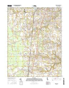
~ Wyoming DE topo map, 1:24000 scale, 7.5 X 7.5 Minute, 2016
Wyoming, Delaware, USGS topographic map dated 2016.
Includes geographic coordinates (latitude and longitude). This topographic map is suitable for hiking, camping, and exploring, or framing it as a wall map.
Printed on-demand using high resolution imagery, on heavy weight and acid free paper, or alternatively on a variety of synthetic materials.
Topos available on paper, Waterproof, Poly, or Tyvek. Usually shipping rolled, unless combined with other folded maps in one order.
- Product Number: USGS-8551536
- Free digital map download (high-resolution, GeoPDF): Wyoming, Delaware (file size: 25 MB)
- Map Size: please refer to the dimensions of the GeoPDF map above
- Weight (paper map): ca. 55 grams
- Map Type: POD USGS Topographic Map
- Map Series: US Topo
- Map Verison: Current
- Cell ID: 49978
- Datum: North American Datum of 1983
- Map Projection: Transverse Mercator
- Map Cell Name: Wyoming
- Grid size: 7.5 X 7.5 Minute
- Date on map: 2016
- Map Scale: 1:24000
- Geographical region: Delaware, United States
Neighboring Maps:
All neighboring USGS topo maps are available for sale online at a variety of scales.
Spatial coverage:
Topo map Wyoming, Delaware, covers the geographical area associated the following places:
- Wyoming - Southwood Acres Mobile Home Park - Highland Acres - Viola - Paris Villa - Woodbury - Derbywood - Winmill - Hidden Pond - Felton Heights - Richardson Estates - Bork Acres - Shady Lane - Pharsalia - Carter Development - Andrews Lake Estates - Meadow Glen - Star Hill Village - Townsend Fields - Lebanon - The Orchard - The Flying Dutchman Mobile Home Park - Lakewind III - Eagles Nest - Del Haven Estates - Felton Station - Beades Estate - Wooden Bridge - Plymouth - Viola Woods - Lakewind - Chimney Hill - Pleasant Hill - Whispering Pines Mobile Home Park - Hudson Trails - Camden - Pennwood - Markeys Mobile Home Park - Palmer Park - Lexington Mill - Canterville - Oxyoke Mobile Home Park - Rockland Hills - Hillside Acres - Lone Star Mobile Home Park - Green Acres Mobile Home Park - London Village - Harrison Knoll - Candlewicke - Scrap Tavern Crossroads - Alexanders Village - Felton Manor - Felton - Summerfield Village - Melbourne Manor - Village at Chestnut Ridge - Tidbury Manor - Riverdale Estates Mobile Home Park - Wyoming Mills - Woodside - Oaknoll - White Hall - Carriage Lane - Rising Sun Mobile Home Park - Rising Sun - Forest Landing - Orchard Acres - Meadowbrook Acres - Browns Corner - Wynn Wood - Voshell Mill - Riverview - Woodfield - Briar Park - The Village at Wild Quail - Burwood Farms - Fairfield Farms - Greenview - Barclay Farms - Star Hill - Breezewood - Del Haven Estates - Brookfield - Pickwick Acres - Newell Creek - Derby Shores - Chaplecroft - Berrytown - The Blades - Mifflin Meadows - Royal Grant - Canterbury - Turnkey - Winmill - Normansmeade - Tidbury Creek Park Mobile Home Park - Burwood - Canterbury Trails - Allee - Garton Development
- Map Area ID: AREA39.12539-75.625-75.5
- Northwest corner Lat/Long code: USGSNW39.125-75.625
- Northeast corner Lat/Long code: USGSNE39.125-75.5
- Southwest corner Lat/Long code: USGSSW39-75.625
- Southeast corner Lat/Long code: USGSSE39-75.5
- Northern map edge Latitude: 39.125
- Southern map edge Latitude: 39
- Western map edge Longitude: -75.625
- Eastern map edge Longitude: -75.5


