
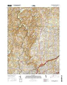
~ Wilmington North DE topo map, 1:24000 scale, 7.5 X 7.5 Minute, 2016
Wilmington North, Delaware, USGS topographic map dated 2016.
Includes geographic coordinates (latitude and longitude). This topographic map is suitable for hiking, camping, and exploring, or framing it as a wall map.
Printed on-demand using high resolution imagery, on heavy weight and acid free paper, or alternatively on a variety of synthetic materials.
Topos available on paper, Waterproof, Poly, or Tyvek. Usually shipping rolled, unless combined with other folded maps in one order.
- Product Number: USGS-8551532
- Free digital map download (high-resolution, GeoPDF): Wilmington North, Delaware (file size: 31 MB)
- Map Size: please refer to the dimensions of the GeoPDF map above
- Weight (paper map): ca. 55 grams
- Map Type: POD USGS Topographic Map
- Map Series: US Topo
- Map Verison: Current
- Cell ID: 49297
- Datum: North American Datum of 1983
- Map Projection: Transverse Mercator
- Map Cell Name: Wilmington North
- Grid size: 7.5 X 7.5 Minute
- Date on map: 2016
- Map Scale: 1:24000
- Geographical region: Delaware, United States
Neighboring Maps:
All neighboring USGS topo maps are available for sale online at a variety of scales.
Spatial coverage:
Topo map Wilmington North, Delaware, covers the geographical area associated the following places:
- Shipley Chase - Shellburne - Silver Springs - Augustine Hills - Montchan - Beechwold - Ringfield - Oak Lane Manor - Surrey Park - Centerville - Dartmouth Woods - Kershaw Acres - Dartmouth Woods II - Penny Acres - Deerbrook II - Weldin Farms - Holiday Hills - West Haven - Carrcroft - Quintynnes - Ridgewood - Montchanin - Kimberly Chase - Madelyn Gardens - Penarth - Westover Hills - Northshire - Longwood - Granogue - Chalfonte - Westbrite - North Hills - Elam - Brandywine Commons - Wilmont - Concord Hills - Nanticoke Farms - Williamhurst - Augustine - Monroe Park - West Park - Meriahnna - Concord Hunt - Forest Hills Park - Club Lane - Ebright - Ways Corner - Phillips Heights - The Ridings of Chadds Ford - Naamans Gardens - Twin Turns Farm - North Minister - Keepsake - Shipley Ridge - Silverbrook - Hollingsworth Development - Devon - Brandywine Perry Park - Delwoods - Tavistock - Northwood - Woodbrook - McDaniel Heights - Bellefonte - Windsor Hills - Winterthur - Rockland - Benton - Twin Oaks - Talleyville - Fairthorne - Pembrey - Perth - Brandywine Hills - Concord Crossing - Woodbine - Beaver Valley - Greenville Place - Lynnfield - Sharpley - Winterset Farms - Brookcroft - Clermont - Cossart Creek - High Point - Brandywine Forge - Rockwood Hills - Cossart Creek - Cossart - Rockland Woods - Deerbrook I - Birch Knoll - Pennington Farm - Gumwood - Greenville - Beacon Hill - Weber Tract - Liftwood - Naamans Manor - Forwood
- Map Area ID: AREA39.87539.75-75.625-75.5
- Northwest corner Lat/Long code: USGSNW39.875-75.625
- Northeast corner Lat/Long code: USGSNE39.875-75.5
- Southwest corner Lat/Long code: USGSSW39.75-75.625
- Southeast corner Lat/Long code: USGSSE39.75-75.5
- Northern map edge Latitude: 39.875
- Southern map edge Latitude: 39.75
- Western map edge Longitude: -75.625
- Eastern map edge Longitude: -75.5


