
~ McCordsville IN topo map, 1:24000 scale, 7.5 X 7.5 Minute, 2016
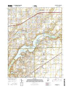
McCordsville, Indiana, USGS topographic map dated 2016.
Includes geographic coordinates (latitude and longitude). This topographic map is suitable for hiking, camping, and exploring, or framing it as a wall map.
Printed on-demand using high resolution imagery, on heavy weight and acid free paper, or alternatively on a variety of synthetic materials.
Topos available on paper, Waterproof, Poly, or Tyvek. Usually shipping rolled, unless combined with other folded maps in one order.
- Product Number: USGS-8538023
- Free digital map download (high-resolution, GeoPDF): McCordsville, Indiana (file size: 28 MB)
- Map Size: please refer to the dimensions of the GeoPDF map above
- Weight (paper map): ca. 55 grams
- Map Type: POD USGS Topographic Map
- Map Series: US Topo
- Map Verison: Current
- Cell ID: 28290
- Datum: North American Datum of 1983
- Map Projection: Transverse Mercator
- Map Cell Name: McCordsville
- Grid size: 7.5 X 7.5 Minute
- Date on map: 2016
- Map Scale: 1:24000
- Geographical region: Indiana, United States
Neighboring Maps:
All neighboring USGS topo maps are available for sale online at a variety of scales.
Spatial coverage:
Topo map McCordsville, Indiana, covers the geographical area associated the following places:
- Brookston Place - Britton Ridge - McCordsville - Sail Place - Quaker Ridge - Geist Woods - Olio - Bridgewater - Tremont - Ashwood - Haig Point - Sweetbriar - Breakwater - Bradford Court - Crosswinds At Windermere - Windermere Villas - Brooks Crossing - Hillsborough - Sand Creek Woods - Turner Grove - Pleasant View - Germantown - Chestnut Hill - Walnut Hills - Cumberland Woods - Devore Place - Glen Abbey At Windermere - Rainbow Highlands - Woodbury - Woods Edge - Indigo Lake - Luxhaven - Sandstone Lakes - Sandstone Ridge - The Hawthorns - Masthead - Sterling Green - Thorny Ridge - Carefree Estates - The Springs of Cambridge - Valley Farms Estates - Hawthorn Hills - The Anchorage - The Portage - Indian Lake - Plantana - Forest Knoll - Collingwood - Sawgrass - Trilobi Hills - Fall Creek Highland - Cumberland Ridge - Lakeside Green - Spyglass Hill - Chateau Court - Sandstone Woods - Windjammer - Heather Point - Brooks - Bucks Creek - Maplewood Mobile Home Park - Heritage Green - Gray Eagle - Highland Springs - Windermere Pointe
- Map Area ID: AREA4039.875-86-85.875
- Northwest corner Lat/Long code: USGSNW40-86
- Northeast corner Lat/Long code: USGSNE40-85.875
- Southwest corner Lat/Long code: USGSSW39.875-86
- Southeast corner Lat/Long code: USGSSE39.875-85.875
- Northern map edge Latitude: 40
- Southern map edge Latitude: 39.875
- Western map edge Longitude: -86
- Eastern map edge Longitude: -85.875


