
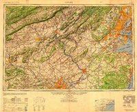
~ Newark NJ topo map, 1:250000 scale, 1 X 2 Degree, Historical, 1949, updated 1949
Newark, New Jersey, USGS topographic map dated 1949.
Includes geographic coordinates (latitude and longitude). This topographic map is suitable for hiking, camping, and exploring, or framing it as a wall map.
Printed on-demand using high resolution imagery, on heavy weight and acid free paper, or alternatively on a variety of synthetic materials.
Topos available on paper, Waterproof, Poly, or Tyvek. Usually shipping rolled, unless combined with other folded maps in one order.
- Product Number: USGS-8527895
- Free digital map download (high-resolution, GeoPDF): Newark, New Jersey (file size: 14 MB)
- Map Size: please refer to the dimensions of the GeoPDF map above
- Weight (paper map): ca. 55 grams
- Map Type: POD USGS Topographic Map
- Map Series: HTMC
- Map Verison: Historical
- Cell ID: 68933
- Scan ID: 707491
- Imprint Year: 1949
- Woodland Tint: Yes
- Aerial Photo Year: 1944
- Datum: Unstated
- Map Projection: Transverse Mercator
- Shaded Relief map: Yes
- Map published by United States Geological Survey
- Map published by United States Army Corps of Engineers
- Map published by United States Army
- Map Language: English
- Scanner Resolution: 508 dpi
- Map Cell Name: Newark
- Grid size: 1 X 2 Degree
- Date on map: 1949
- Map Scale: 1:250000
- Geographical region: New Jersey, United States
Neighboring Maps:
All neighboring USGS topo maps are available for sale online at a variety of scales.
Spatial coverage:
Topo map Newark, New Jersey, covers the geographical area associated the following places:
- Jamestown Village - The Heathers - Scobeyville - Regency Park Towers - Ritter Estates - Tylersport - Hasbrouck Heights - Hacklebarney - Plainfield - Furmans Corner - Mile Hollow - Charmingdale - Lynnport - Milnesville - Newportville - Meadow Wick - Rosecliff - Seemsville - Waynes Brooke - Dreibelbis - Bridgetown - Yerkes - Logan - Krassdale - East Spotswood - Colmar - Green Curve Heights - Port Richmond - Pin Oak Estates - Bushkill Center - Brookline - Malins - Pittville - Montgomery Crossing - Juliustown - West Leesport - Union City - Blackburn Farm - Coventry House - Titusville - Morgan - Sunnybrook - Oxford Valley - Winfield - Tennent - Tabor - Millers - Mexico (historical) - Riverside - Roxborough - Rockville - Readington - Knauers - Midland Park - Leinbachs - Ringtown - Meriden - Midway - Palmer Heights - Woodgate - Wismer - Lakewood - Somerton - Mountain Park - Woodlawn - Finland - Sharper - Fairfield - Hazle Brook - Harley Corners - New Dorp - Green Tree Acres - Phoenix - Ancient Oaks - Kingston - Bingen - Cambridge Reserve - Woxall - Andreas - Prospect Point - Zieglersville - Glendale - Buttzville - Norrington Knoll - Polk Valley - Croydon Acres - Fieldville - Meyersville - Aquetong - Port Murray - Riverton - East Falls - Lewistown - Pequest - Shacks Corner - Minesite - New Dorp Beach - Welsh Woods - Bergen Mills - Eckley
- Map Area ID: AREA4140-76-74
- Northwest corner Lat/Long code: USGSNW41-76
- Northeast corner Lat/Long code: USGSNE41-74
- Southwest corner Lat/Long code: USGSSW40-76
- Southeast corner Lat/Long code: USGSSE40-74
- Northern map edge Latitude: 41
- Southern map edge Latitude: 40
- Western map edge Longitude: -76
- Eastern map edge Longitude: -74


