
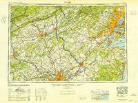
~ Newark NJ topo map, 1:250000 scale, 1 X 2 Degree, Historical, 1949
Newark, New Jersey, USGS topographic map dated 1949.
Includes geographic coordinates (latitude and longitude). This topographic map is suitable for hiking, camping, and exploring, or framing it as a wall map.
Printed on-demand using high resolution imagery, on heavy weight and acid free paper, or alternatively on a variety of synthetic materials.
Topos available on paper, Waterproof, Poly, or Tyvek. Usually shipping rolled, unless combined with other folded maps in one order.
- Product Number: USGS-8527893
- Free digital map download (high-resolution, GeoPDF): Newark, New Jersey (file size: 17 MB)
- Map Size: please refer to the dimensions of the GeoPDF map above
- Weight (paper map): ca. 55 grams
- Map Type: POD USGS Topographic Map
- Map Series: HTMC
- Map Verison: Historical
- Cell ID: 68933
- Scan ID: 255456
- Woodland Tint: Yes
- Aerial Photo Year: 1944
- Datum: NAD27
- Map Projection: Transverse Mercator
- Map published by United States Geological Survey
- Map Language: English
- Scanner Resolution: 600 dpi
- Map Cell Name: Newark
- Grid size: 1 X 2 Degree
- Date on map: 1949
- Map Scale: 1:250000
- Geographical region: New Jersey, United States
Neighboring Maps:
All neighboring USGS topo maps are available for sale online at a variety of scales.
Spatial coverage:
Topo map Newark, New Jersey, covers the geographical area associated the following places:
- West Farms - North Edison - Glen Alpin - Glenloch - Westbury - Fairview - Five Points - Steinsville - Green Curve Heights - Treyburn - Logansville - The Highlands - Burholme - Neshaminy (historical) - Dorneyville - Montville - The Orchards - Olney - Fiddletown - Klinesville - Union Valley - East Burlington - Indian Crest Farms - Greenwich Village - Bath Addition - Tierneys Corner - Mount Hope - Oley Line - Churchville - North Wales - Bells Crossing - Laros (historical) - Bristol Terrace Number One - Van Dorans Mills - De La Salle - Green Countrie Village - Laverock - Howellville - Elmwood Park - Oak Hill - Yardville Heights - Berkshire Heights - East Brunswick - Davisville - Phoenix - Golden Age Manor - Arneys Mount - Foxcroft Square - Whitesville - Cottrell Corners - Crossroads - Harrison Estate - Lowell Hills - Gwynedd Knoll - Keasbey - Inglewood - Krocksville - Gwynmont Farms - Hendricks - Abington - Belfry - Green Tree - Sandhill - Huntsville - Woodbridge - Mechanicsville - Montgomery Brooke - Taylortown - College Heights - New Vernon - Penns Neck - Mountainville - Sutton Park - Dublin Crossing - Crossmans - Croton - Pequannock - Eagleville - Creamery - Glenn Rose - Washington - Shady Lawn Manor - Providence Crossing - Daylesford - Heathcote - Grandin - Henderson Park - Junedale - Erwinna - Bridgepoint - Clearbrook Park - Rhawnhurst - West Trenton - Madison Heights - Troy Hills - Schoenersville - Cedar Hollow - Freewood Acres - Robert Bruce - Collegeville Arms
- Map Area ID: AREA4140-76-74
- Northwest corner Lat/Long code: USGSNW41-76
- Northeast corner Lat/Long code: USGSNE41-74
- Southwest corner Lat/Long code: USGSSW40-76
- Southeast corner Lat/Long code: USGSSE40-74
- Northern map edge Latitude: 41
- Southern map edge Latitude: 40
- Western map edge Longitude: -76
- Eastern map edge Longitude: -74


