
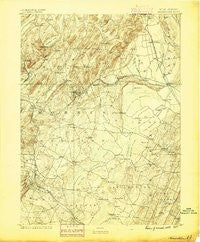
~ Morristown NJ topo map, 1:62500 scale, 15 X 15 Minute, Historical, 1888, updated 1888
Morristown, New Jersey, USGS topographic map dated 1888.
Includes geographic coordinates (latitude and longitude). This topographic map is suitable for hiking, camping, and exploring, or framing it as a wall map.
Printed on-demand using high resolution imagery, on heavy weight and acid free paper, or alternatively on a variety of synthetic materials.
Topos available on paper, Waterproof, Poly, or Tyvek. Usually shipping rolled, unless combined with other folded maps in one order.
- Product Number: USGS-8527032
- Free digital map download (high-resolution, GeoPDF): Morristown, New Jersey (file size: 7 MB)
- Map Size: please refer to the dimensions of the GeoPDF map above
- Weight (paper map): ca. 55 grams
- Map Type: POD USGS Topographic Map
- Map Series: HTMC
- Map Verison: Historical
- Cell ID: 57904
- Scan ID: 255268
- Imprint Year: 1888
- Datum: Unstated
- Map Projection: Unstated
- Map published by United States Geological Survey
- Map Language: English
- Scanner Resolution: 600 dpi
- Map Cell Name: Morristown
- Grid size: 15 X 15 Minute
- Date on map: 1888
- Map Scale: 1:62500
- Geographical region: New Jersey, United States
Neighboring Maps:
All neighboring USGS topo maps are available for sale online at a variety of scales.
Spatial coverage:
Topo map Morristown, New Jersey, covers the geographical area associated the following places:
- Towaco - Whippany - Loantaka Estates - Fairfield - Pines Lake - Littleton - Madison - Hibernia - Madison Heights - Beach Glen - Smoke Rise - Yardley Village - Taylortown - Shady Lawn Manor - Beaufort - Lake Parsippany - Pompton Plains - Parsippany - Monroe - Lincoln Park - Fayson Lakes - Lower Montville - Finns Trailer Court - Northfield - Caldwell - Malapardis - Westville - Two Bridges - Morristown - Mountain Lakes - Hanover - Rockaway Valley - Pine Brook - Riverdale - Boonton - Hanover Neck - Florham Park - Livingston - Marcella - Morris Plains - Pompton - Lake Telemark - Brook Valley - Meriden - Fox Hill - Fairwoods - Lake Hiawatha - Franklin - Birch Hills - Newstead - Powerville - Essex Fells - West Caldwell - Rosedale Village - Troy Hills - Montville - Morehousetown - Wayne - Cobbs Corner - Saint Cloud - East Hanover - Pleasantdale - Afton - Ridgedale Park - Packanack Lake - Pequannock - North Caldwell - Lake Arrowhead - Tabor - Roseland - Mountain View - Knollwood - Clinton - Hutton Park - Jacksonville - Cedar Knolls - Lyonsville - Denville - Newstead North
- Map Area ID: AREA4140.75-74.5-74.25
- Northwest corner Lat/Long code: USGSNW41-74.5
- Northeast corner Lat/Long code: USGSNE41-74.25
- Southwest corner Lat/Long code: USGSSW40.75-74.5
- Southeast corner Lat/Long code: USGSSE40.75-74.25
- Northern map edge Latitude: 41
- Southern map edge Latitude: 40.75
- Western map edge Longitude: -74.5
- Eastern map edge Longitude: -74.25


