
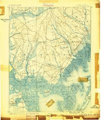
~ Little Egg Harbor NJ topo map, 1:62500 scale, 15 X 15 Minute, Historical, 1888
Little Egg Harbor, New Jersey, USGS topographic map dated 1888.
Includes geographic coordinates (latitude and longitude). This topographic map is suitable for hiking, camping, and exploring, or framing it as a wall map.
Printed on-demand using high resolution imagery, on heavy weight and acid free paper, or alternatively on a variety of synthetic materials.
Topos available on paper, Waterproof, Poly, or Tyvek. Usually shipping rolled, unless combined with other folded maps in one order.
- Product Number: USGS-8527002
- Free digital map download (high-resolution, GeoPDF): Little Egg Harbor, New Jersey (file size: 8 MB)
- Map Size: please refer to the dimensions of the GeoPDF map above
- Weight (paper map): ca. 55 grams
- Map Type: POD USGS Topographic Map
- Map Series: HTMC
- Map Verison: Historical
- Cell ID: 63727
- Scan ID: 255249
- Datum: Unstated
- Map Projection: Unstated
- Map published by United States Geological Survey
- Map Language: English
- Scanner Resolution: 600 dpi
- Map Cell Name: Tuckerton
- Grid size: 15 X 15 Minute
- Date on map: 1888
- Map Scale: 1:62500
- Geographical region: New Jersey, United States
Neighboring Maps:
All neighboring USGS topo maps are available for sale online at a variety of scales.
Spatial coverage:
Topo map Little Egg Harbor, New Jersey, covers the geographical area associated the following places:
- Giffordtown - Johnsontown - West Creek - Mystic Island - Cedar Run - New Gretna - Coxstown - Sim Place - Eagleswood Village - Nugentown - Deerhaven - Tuckerton - Higbeeville - Munion Field - Port Republic - Leektown - Stafford Forge - Merrygold - Bass River - Manahawkin - Mayetta - Penn Place - Scow Landing - West Tuckerton Landing - Deer Lake Park - West Tuckerton - Beach Haven Heights - Spraguetown - Warren Grove - Parkertown - Lakeview Terrace - Holgate - Parkers Landing - Oyster Creek - Staffordville - Tuckerton Shores - Ocean Acres
- Map Area ID: AREA39.7539.5-74.5-74.25
- Northwest corner Lat/Long code: USGSNW39.75-74.5
- Northeast corner Lat/Long code: USGSNE39.75-74.25
- Southwest corner Lat/Long code: USGSSW39.5-74.5
- Southeast corner Lat/Long code: USGSSE39.5-74.25
- Northern map edge Latitude: 39.75
- Southern map edge Latitude: 39.5
- Western map edge Longitude: -74.5
- Eastern map edge Longitude: -74.25


