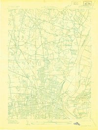
~ Windsor CT topo map, 1:24000 scale, 7.5 X 7.5 Minute, Historical, 1928
Windsor, Connecticut, USGS topographic map dated 1928.
Includes geographic coordinates (latitude and longitude). This topographic map is suitable for hiking, camping, and exploring, or framing it as a wall map.
Printed on-demand using high resolution imagery, on heavy weight and acid free paper, or alternatively on a variety of synthetic materials.
Topos available on paper, Waterproof, Poly, or Tyvek. Usually shipping rolled, unless combined with other folded maps in one order.
- Product Number: USGS-8506690
- Free digital map download (high-resolution, GeoPDF): Windsor, Connecticut (file size: 6 MB)
- Map Size: please refer to the dimensions of the GeoPDF map above
- Weight (paper map): ca. 55 grams
- Map Type: POD USGS Topographic Map
- Map Series: HTMC
- Map Verison: Historical
- Cell ID: 19512
- Scan ID: 330793
- Woodland Tint: Yes
- Aerial Photo Year: 1928
- Datum: NAD
- Map Projection: Polyconic
- Advance: Yes
- Planimetric: Yes
- Map published by United States Geological Survey
- Keywords: Nonstandard Press Run
- Map Language: English
- Scanner Resolution: 600 dpi
- Map Cell Name: Hartford North
- Grid size: 7.5 X 7.5 Minute
- Date on map: 1928
- Map Scale: 1:24000
- Geographical region: Connecticut, United States
Neighboring Maps:
All neighboring USGS topo maps are available for sale online at a variety of scales.
Spatial coverage:
Topo map Windsor, Connecticut, covers the geographical area associated the following places:
- Smith Tower Housing - Fernridge Place - Parkville - West Hill - Hartford - West Hartford - Windsor - Cottage Grove - Dutch Point Colony - Wilson - Childrens Village of the Hartford Orphan Asylum - Blue Hills - Stowe Village Housing Project - Bloomfield
- Map Area ID: AREA41.87541.75-72.75-72.625
- Northwest corner Lat/Long code: USGSNW41.875-72.75
- Northeast corner Lat/Long code: USGSNE41.875-72.625
- Southwest corner Lat/Long code: USGSSW41.75-72.75
- Southeast corner Lat/Long code: USGSSE41.75-72.625
- Northern map edge Latitude: 41.875
- Southern map edge Latitude: 41.75
- Western map edge Longitude: -72.75
- Eastern map edge Longitude: -72.625