
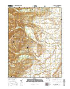
~ Pitchpine Mountain CO topo map, 1:24000 scale, 7.5 X 7.5 Minute, 2016
Pitchpine Mountain, Colorado, USGS topographic map dated 2016.
Includes geographic coordinates (latitude and longitude). This topographic map is suitable for hiking, camping, and exploring, or framing it as a wall map.
Printed on-demand using high resolution imagery, on heavy weight and acid free paper, or alternatively on a variety of synthetic materials.
Topos available on paper, Waterproof, Poly, or Tyvek. Usually shipping rolled, unless combined with other folded maps in one order.
- Product Number: USGS-8369763
- Free digital map download (high-resolution, GeoPDF): Pitchpine Mountain, Colorado (file size: 26 MB)
- Map Size: please refer to the dimensions of the GeoPDF map above
- Weight (paper map): ca. 55 grams
- Map Type: POD USGS Topographic Map
- Map Series: US Topo
- Map Verison: Current
- Cell ID: 35459
- Datum: North American Datum of 1983
- Map Projection: Transverse Mercator
- Map Cell Name: Pitchpine Mountain
- Grid size: 7.5 X 7.5 Minute
- Date on map: 2016
- Map Scale: 1:24000
- Geographical region: Colorado, United States
Neighboring Maps:
All neighboring USGS topo maps are available for sale online at a variety of scales.
Spatial coverage:
Topo map Pitchpine Mountain, Colorado, covers the geographical area associated the following places:
- Emigh Ranch - Butler Creek - Roaring Ditch - Sunday Creek Ditch - Red Canyon - Briggs and Bohn Ditch - Eriki Ditch - Erika Ditch - Livingston Park - Norris Creek - Dora Ditch - Middle Rainbow Lake - Brands Ranch - Higho Ditch - Lillie Ditch - Joe Mine - Norris Ranch - Butler Ditch Number 3 - Red Canyon Reservoir - Earnest Ditch - Beaver Ditch - Butte Creek - Pitchpine Mountain - Crystal Mine - Butler Ditch Number 2 - Hillside Ditch - Pedad Mine - South Fork Beaver Creek - Hodgson Ditch - Lone Pine Ditch - Ceanothuse Lake - Canon Ditch - Japanese Davidson Ditch - Mitchell Ditch - Heineman Ditch - Carlstrom Brothers Ranch - Manville Ditch Number 2 - Spar Mine - Open A Diamond Ditch - Wolfer Ditch - Aspin Ditch - Norris Ditch - Spring Creek - Butler Ditch Number 4 - Timber Ditch - Pearl Ditch - Spring Gulch Ditch - Wolfer Ditch - Irvine Ranch - Lower Rainbow Lake - Butler Ditch - Norrell Ditch - Sunday Creek - Raspberry Creek
- Map Area ID: AREA40.7540.625-106.625-106.5
- Northwest corner Lat/Long code: USGSNW40.75-106.625
- Northeast corner Lat/Long code: USGSNE40.75-106.5
- Southwest corner Lat/Long code: USGSSW40.625-106.625
- Southeast corner Lat/Long code: USGSSE40.625-106.5
- Northern map edge Latitude: 40.75
- Southern map edge Latitude: 40.625
- Western map edge Longitude: -106.625
- Eastern map edge Longitude: -106.5


