
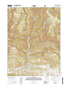
~ Rifle Falls CO topo map, 1:24000 scale, 7.5 X 7.5 Minute, 2016
Rifle Falls, Colorado, USGS topographic map dated 2016.
Includes geographic coordinates (latitude and longitude). This topographic map is suitable for hiking, camping, and exploring, or framing it as a wall map.
Printed on-demand using high resolution imagery, on heavy weight and acid free paper, or alternatively on a variety of synthetic materials.
Topos available on paper, Waterproof, Poly, or Tyvek. Usually shipping rolled, unless combined with other folded maps in one order.
- Product Number: USGS-8365470
- Free digital map download (high-resolution, GeoPDF): Rifle Falls, Colorado (file size: 31 MB)
- Map Size: please refer to the dimensions of the GeoPDF map above
- Weight (paper map): ca. 55 grams
- Map Type: POD USGS Topographic Map
- Map Series: US Topo
- Map Verison: Current
- Cell ID: 37909
- Datum: North American Datum of 1983
- Map Projection: Transverse Mercator
- Map Cell Name: Rifle Falls
- Grid size: 7.5 X 7.5 Minute
- Date on map: 2016
- Map Scale: 1:24000
- Geographical region: Colorado, United States
Neighboring Maps:
All neighboring USGS topo maps are available for sale online at a variety of scales.
Spatial coverage:
Topo map Rifle Falls, Colorado, covers the geographical area associated the following places:
- Spring Cow Camp - West Elk Forest Service Station - Lily Mine - Huffman Gulch - Cherry Creek - Garfield Mine - Bear Lake - West Elk Reservoir - Blue Spruce Campground - Park Dam - Rifle Mountain Park - Coulter Mesa - Dry Rifle Creek - Park Reservoir - Grass Valley Canal - George Creek - Grandview Mine - Elk Park - Beef Draw - Rifle Falls Fish Hatchery - Sunshine Mine - West Elk Stock Driveway - Elk Van Tunnel and UV Claims - Sawmill Gulch - Long Park - Rifle Mine - Rifle Falls
- Map Area ID: AREA39.7539.625-107.75-107.625
- Northwest corner Lat/Long code: USGSNW39.75-107.75
- Northeast corner Lat/Long code: USGSNE39.75-107.625
- Southwest corner Lat/Long code: USGSSW39.625-107.75
- Southeast corner Lat/Long code: USGSSE39.625-107.625
- Northern map edge Latitude: 39.75
- Southern map edge Latitude: 39.625
- Western map edge Longitude: -107.75
- Eastern map edge Longitude: -107.625


