
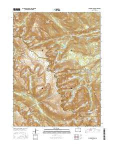
~ McHenrys Peak CO topo map, 1:24000 scale, 7.5 X 7.5 Minute, 2016
McHenrys Peak, Colorado, USGS topographic map dated 2016.
Includes geographic coordinates (latitude and longitude). This topographic map is suitable for hiking, camping, and exploring, or framing it as a wall map.
Printed on-demand using high resolution imagery, on heavy weight and acid free paper, or alternatively on a variety of synthetic materials.
Topos available on paper, Waterproof, Poly, or Tyvek. Usually shipping rolled, unless combined with other folded maps in one order.
- Product Number: USGS-8364460
- Free digital map download (high-resolution, GeoPDF): McHenrys Peak, Colorado (file size: 31 MB)
- Map Size: please refer to the dimensions of the GeoPDF map above
- Weight (paper map): ca. 55 grams
- Map Type: POD USGS Topographic Map
- Map Series: US Topo
- Map Verison: Current
- Cell ID: 28404
- Datum: North American Datum of 1983
- Map Projection: Transverse Mercator
- Map Cell Name: McHenrys Peak
- Grid size: 7.5 X 7.5 Minute
- Date on map: 2016
- Map Scale: 1:24000
- Geographical region: Colorado, United States
Neighboring Maps:
All neighboring USGS topo maps are available for sale online at a variety of scales.
Spatial coverage:
Topo map McHenrys Peak, Colorado, covers the geographical area associated the following places:
- Hayden Spire - Murphy Lake - Ribbon Falls - Beaver Mountain - Snowdrift Peak - Little Matterhorn - Embryo Lake - Sprague Mountain - Jewel Lake - Castle Rock - Sky Pond - Glacier Gorge Junction - Andrews Pass - Chaos Canyon - Rocky Mountain National Park - Green Lake - Frozen Lake - Loch Vale Trail - Grace Falls - Lake Nokoni - Timberline Falls - Tourmaline Gorge - Hourglass Lake - Forest Canyon - Sprague Glacier - Taylor Peak - Mount Wuh - War Dance Falls - Glacier Gorge - Loomis Lake - Ptarmigan Point - Ptarmigan Mountain - Emerald Lake - Notchtop Mountain - J P Chitwood Grave - Ptarmigan Creek - Arrowhead - Marguerite Falls - Spruce Canyon - Hallett Creek - Pettingell Lake - Nymph Lake - Black Lake - McHenrys Peak - Flattop Mountain - Irene Lake - Ptarmigan Lake - The Gash - Andrews Tarn - Glacier Falls - Spruce Lake - Two Rivers Lake - Raspberry Park - Dream Lake - Fern Lake - Shelf Lake - The Pool - Glacier Creek Trail - Chaos Creek - Loch Vale - Rocky Mountain National Park Wilderness - Tourmaline Lake - Bench Lake - Mills Lake - Lake Haiyaha - Blue Lake - Alva B Adams Tunnel - Knobtop Mountain - Fern Creek - Stones Peak - Alberta Falls - Marigold Lake - Tyndall Glacier - Rainbow Lake - Marigold Pond - Cub Lake - Sprague Pass - Odessa Lake - Otis Peak - Fern Falls - Bear Lake - Doctor Thornton R Sampson Grave - Lost Brook - Half Mountain - Icy Brook - Tyndall Gorge - North Inlet Trail - Lake of Glass - Bighorn Flats - Thatchtop - The Loch - Flattop Mountain Trail - Windy Gulch - Ptarmigan Pass - Powell Peak - Gabletop Mountain - Mill Creek Basin - Joe Mills Mountain - Lake Nanita - Lake Nanita Trail
- Map Area ID: AREA40.37540.25-105.75-105.625
- Northwest corner Lat/Long code: USGSNW40.375-105.75
- Northeast corner Lat/Long code: USGSNE40.375-105.625
- Southwest corner Lat/Long code: USGSSW40.25-105.75
- Southeast corner Lat/Long code: USGSSE40.25-105.625
- Northern map edge Latitude: 40.375
- Southern map edge Latitude: 40.25
- Western map edge Longitude: -105.75
- Eastern map edge Longitude: -105.625


