
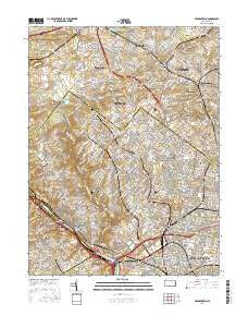
~ Germantown PA topo map, 1:24000 scale, 7.5 X 7.5 Minute, 2016
Germantown, Pennsylvania, USGS topographic map dated 2016.
Includes geographic coordinates (latitude and longitude). This topographic map is suitable for hiking, camping, and exploring, or framing it as a wall map.
Printed on-demand using high resolution imagery, on heavy weight and acid free paper, or alternatively on a variety of synthetic materials.
Topos available on paper, Waterproof, Poly, or Tyvek. Usually shipping rolled, unless combined with other folded maps in one order.
- Product Number: USGS-8259849
- Free digital map download (high-resolution, GeoPDF): Germantown, Pennsylvania (file size: 29 MB)
- Map Size: please refer to the dimensions of the GeoPDF map above
- Weight (paper map): ca. 55 grams
- Map Type: POD USGS Topographic Map
- Map Series: US Topo
- Map Verison: Current
- Cell ID: 17118
- Datum: North American Datum of 1983
- Map Projection: Transverse Mercator
- Map Cell Name: Germantown
- Grid size: 7.5 X 7.5 Minute
- Date on map: 2016
- Map Scale: 1:24000
- Geographical region: Pennsylvania, United States
Neighboring Maps:
All neighboring USGS topo maps are available for sale online at a variety of scales.
Spatial coverage:
Topo map Germantown, Pennsylvania, covers the geographical area associated the following places:
- Lamott - Ardsley - Lancasterville - Tabor - Whitemarsh - East Oak Lane - Pencoyd - Allegheny West - Rosemore Gardens - Cedarbrook Hill - Elkins Park House - Chestnut Hill - West Laurel Hill - Penn Weldy - Ivy Hill - Weldon - East Mount Airy - Laverock - Pencoyd Park - Jenkintown - Germantown - West Mount Airy - Cedarbrook - Manayunk - Edge Hill - Mermaid - Arlingham - Bala-Cynwyd - McMoran Park - Gravers - Sunnybrook - Kennedy House - Upsal - Hunting Park - Erdenheim - Nicetown-Tioga - Nicetown - Somerville - Glenside - Pittville - Chelten Hills - Mount Airy - Tioga - Fitzwatertown - West Manayunk - Chopersville - Benson East - Oak Summit - Roslyn Heights - Hillside (historical) - Wyncote - Saint Martins - Roxborough - West Oak Lane - Lynnwood Gardens - Wayne Junction - Valley Green - East Falls - Highland - The Estates at Whitemarsh Hills - Mount Pleasant - Abbotsford Homes - Alden Park Manor - Cynwyd - Wynnefield Heights - Morton - Oreland - Latches Lane - Enfield - Elkins Park - Glen Willow - Breyer - Cynwyd Estates - Lynnewood Gardens - Feltonville - Wyoming - Upper Roxborough - Tulpohocken - Five Points - Mount Vernon Gardens - Manatawna - Andorra - Wister - East Oreland - Logan - Shawmont - Fishers - Allen Lane - Williams - Academyville - Wissahickon - Wyndmoor - Melrose Park - Flourtown - Carpenter - Fern Rock - North Hills - Ashbourne - Whitemarsh Woods - Sutton Terrace
- Map Area ID: AREA40.12540-75.25-75.125
- Northwest corner Lat/Long code: USGSNW40.125-75.25
- Northeast corner Lat/Long code: USGSNE40.125-75.125
- Southwest corner Lat/Long code: USGSSW40-75.25
- Southeast corner Lat/Long code: USGSSE40-75.125
- Northern map edge Latitude: 40.125
- Southern map edge Latitude: 40
- Western map edge Longitude: -75.25
- Eastern map edge Longitude: -75.125


