
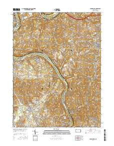
~ Carmichaels PA topo map, 1:24000 scale, 7.5 X 7.5 Minute, 2016
Carmichaels, Pennsylvania, USGS topographic map dated 2016.
Includes geographic coordinates (latitude and longitude). This topographic map is suitable for hiking, camping, and exploring, or framing it as a wall map.
Printed on-demand using high resolution imagery, on heavy weight and acid free paper, or alternatively on a variety of synthetic materials.
Topos available on paper, Waterproof, Poly, or Tyvek. Usually shipping rolled, unless combined with other folded maps in one order.
- Product Number: USGS-8252278
- Free digital map download (high-resolution, GeoPDF): Carmichaels, Pennsylvania (file size: 29 MB)
- Map Size: please refer to the dimensions of the GeoPDF map above
- Weight (paper map): ca. 55 grams
- Map Type: POD USGS Topographic Map
- Map Series: US Topo
- Map Verison: Current
- Cell ID: 7326
- Datum: North American Datum of 1983
- Map Projection: Transverse Mercator
- Map Cell Name: Carmichaels
- Grid size: 7.5 X 7.5 Minute
- Date on map: 2016
- Map Scale: 1:24000
- Geographical region: Pennsylvania, United States
Neighboring Maps:
All neighboring USGS topo maps are available for sale online at a variety of scales.
Spatial coverage:
Topo map Carmichaels, Pennsylvania, covers the geographical area associated the following places:
- Republic - Keeny Row - Stringtown - Isabella - Arensburg - Lamberton - Merrittstown - Fairdale - Thompson Number 2 - West Bend - Heistersburg - Crucible - Antram - Adah - Neil Corner - Millsboro - Ralph - Palmer - Melrose - Nemacolin - Edenborn - East Riverside - Cumberland Village - Rices Landing - Luzerne - Gates - Superior - Church Hill - Allison Heights - Penncraft - Hibbs - Carmichaels - East Millsboro - Thompson Number 1 - Tower Hill Number Two - Tower Hill Number One
- Map Area ID: AREA4039.875-80-79.875
- Northwest corner Lat/Long code: USGSNW40-80
- Northeast corner Lat/Long code: USGSNE40-79.875
- Southwest corner Lat/Long code: USGSSW39.875-80
- Southeast corner Lat/Long code: USGSSE39.875-79.875
- Northern map edge Latitude: 40
- Southern map edge Latitude: 39.875
- Western map edge Longitude: -80
- Eastern map edge Longitude: -79.875


