
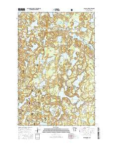
~ Balsam Lake MN topo map, 1:24000 scale, 7.5 X 7.5 Minute, 2016
Balsam Lake, Minnesota, USGS topographic map dated 2016.
Includes geographic coordinates (latitude and longitude). This topographic map is suitable for hiking, camping, and exploring, or framing it as a wall map.
Printed on-demand using high resolution imagery, on heavy weight and acid free paper, or alternatively on a variety of synthetic materials.
Topos available on paper, Waterproof, Poly, or Tyvek. Usually shipping rolled, unless combined with other folded maps in one order.
- Product Number: USGS-8117913
- Free digital map download (high-resolution, GeoPDF): Balsam Lake, Minnesota (file size: 27 MB)
- Map Size: please refer to the dimensions of the GeoPDF map above
- Weight (paper map): ca. 55 grams
- Map Type: POD USGS Topographic Map
- Map Series: US Topo
- Map Verison: Current
- Cell ID: 2286
- Datum: North American Datum of 1983
- Map Projection: Transverse Mercator
- Map Cell Name: Balsam Lake
- Grid size: 7.5 X 7.5 Minute
- Date on map: 2016
- Map Scale: 1:24000
- Geographical region: Minnesota, United States
Neighboring Maps:
All neighboring USGS topo maps are available for sale online at a variety of scales.
Spatial coverage:
Topo map Balsam Lake, Minnesota, covers the geographical area associated the following places:
- Little Porky Lake - Marcell Experimental Forest - Brown Lake - Long Lake - Moon Lake - Spruce Lake - King Lake - Birch Lake - George Lake - Stumple Lake - Balsam Lake - Whiskey Lake - Township of Balsam - Teigland Family Cemetery - Sawyer Lake - Bass Lake - Nickel Lake - White Porky Lake - Scrapper Lake - Haskell Lake - Marble Lake - Lum Lake - Buck Lake - Bog Lake - Courtney Lake - Burrows Lake - Balsam Lake - Bolduc Seaplane Base - Beaver Lake - Willeys Lake - Wilson Lake - King Lake Group Lake Outlet Structure Dam - Buckman Lake - Tubby Lake - Hunter Lake - Lake Mary - Eagle Lake - Blandin Lake - Little Otter Lake - Moss Lake - Balsam Lake Dam - Spring Lake - Lincoln Lake - White Swan Lake - Bluebill Lake - Marcell Experimental Forest - Balsam Cemetery - Barwise Lake - Gunny Sack Lake - Balsam Chapel
- Map Area ID: AREA47.62547.5-93.5-93.375
- Northwest corner Lat/Long code: USGSNW47.625-93.5
- Northeast corner Lat/Long code: USGSNE47.625-93.375
- Southwest corner Lat/Long code: USGSSW47.5-93.5
- Southeast corner Lat/Long code: USGSSE47.5-93.375
- Northern map edge Latitude: 47.625
- Southern map edge Latitude: 47.5
- Western map edge Longitude: -93.5
- Eastern map edge Longitude: -93.375


