
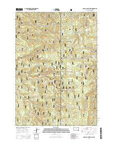
~ Old Baldy Mountain SD topo map, 1:24000 scale, 7.5 X 7.5 Minute, 2015
Old Baldy Mountain, South Dakota, USGS topographic map dated 2015.
Includes geographic coordinates (latitude and longitude). This topographic map is suitable for hiking, camping, and exploring, or framing it as a wall map.
Printed on-demand using high resolution imagery, on heavy weight and acid free paper, or alternatively on a variety of synthetic materials.
Topos available on paper, Waterproof, Poly, or Tyvek. Usually shipping rolled, unless combined with other folded maps in one order.
- Product Number: USGS-8012889
- Free digital map download (high-resolution, GeoPDF): Old Baldy Mountain, South Dakota (file size: 25 MB)
- Map Size: please refer to the dimensions of the GeoPDF map above
- Weight (paper map): ca. 55 grams
- Map Type: POD USGS Topographic Map
- Map Series: US Topo
- Map Verison: Current
- Cell ID: 33073
- Datum: North American Datum of 1983
- Map Projection: Transverse Mercator
- Map Cell Name: Old Baldy Mountain
- Grid size: 7.5 X 7.5 Minute
- Date on map: 2015
- Map Scale: 1:24000
- Geographical region: South Dakota, United States
Neighboring Maps:
All neighboring USGS topo maps are available for sale online at a variety of scales.
Spatial coverage:
Topo map Old Baldy Mountain, South Dakota, covers the geographical area associated the following places:
- Miller Spring - Keenan Properties Mine - Klondike School - Wagon Canyon Spring - Seeley Ranch - Riflepit Canyon - Moonshine Gulch - Cement Ridge - Two Way Spring - Kirley Gulch - Smith Draw - Rattlesnake Spring Number 3 - Old Baldy Mountain - Buffalo Park - Giant-Volney Mine - Schoolhouse Spring - Pettigrew Trail - Balm of Gilead Spring - Mathews Ranch - Rattlesnake Spring Number 2 - Rough and Ready Mine - South Beaver Creek - Filmore Mine - Bonanza Gulch - Pole Cabin Spring - Sager Ranch - Van Horn Spring - Schoolhouse Gulch - Stearns Park - Shirttail Gulch - Spearfish and Centaur Mine - Rattlesnake Spring Number 1 - South Fork Schoolhouse Gulch - Middle Beaver Creek - Lone Grave Spring - Riflepit Canyon - Guidinger Spring - Lightning Creek - Welcome - Mineral Hill - Bald Mountain - Lap Circle Ranch - Sand Creek Mine - North Beaver Creek - Geranium Park - Ladyfinger Gulch - Billie Spring - Me George Spring
- Map Area ID: AREA44.37544.25-104.125-104
- Northwest corner Lat/Long code: USGSNW44.375-104.125
- Northeast corner Lat/Long code: USGSNE44.375-104
- Southwest corner Lat/Long code: USGSSW44.25-104.125
- Southeast corner Lat/Long code: USGSSE44.25-104
- Northern map edge Latitude: 44.375
- Southern map edge Latitude: 44.25
- Western map edge Longitude: -104.125
- Eastern map edge Longitude: -104


