
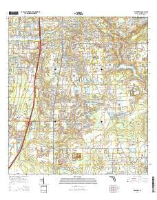
~ Riverview FL topo map, 1:24000 scale, 7.5 X 7.5 Minute, 2015
Riverview, Florida, USGS topographic map dated 2015.
Includes geographic coordinates (latitude and longitude). This topographic map is suitable for hiking, camping, and exploring, or framing it as a wall map.
Printed on-demand using high resolution imagery, on heavy weight and acid free paper, or alternatively on a variety of synthetic materials.
Topos available on paper, Waterproof, Poly, or Tyvek. Usually shipping rolled, unless combined with other folded maps in one order.
- Product Number: USGS-8006114
- Free digital map download (high-resolution, GeoPDF): Riverview, Florida (file size: 31 MB)
- Map Size: please refer to the dimensions of the GeoPDF map above
- Weight (paper map): ca. 55 grams
- Map Type: POD USGS Topographic Map
- Map Series: US Topo
- Map Verison: Current
- Cell ID: 38074
- Datum: North American Datum of 1983
- Map Projection: Transverse Mercator
- Map Cell Name: Riverview
- Grid size: 7.5 X 7.5 Minute
- Date on map: 2015
- Map Scale: 1:24000
- Geographical region: Florida, United States
Neighboring Maps:
All neighboring USGS topo maps are available for sale online at a variety of scales.
Spatial coverage:
Topo map Riverview, Florida, covers the geographical area associated the following places:
- Summer Springs - Hurley Manor - Waterford on the Alafia - Balm - Indian Hills - Bell Creek Hammocks North - Amber Sweet Farms - South Fork - Boyette Ridge Estates - Symmes Acres - Jojo - Emerald Creek - Clubhouse Estates at Summerfield - River Vista - Creek View - Riverview Estates - Tromble - Hickory Creek - Rivers Edge - North Street Oaks - Riverlachen - Colonial Hills - Bullfrog Acres - Lonesome Pines Estates - Moss Landing - Elkton - Riverview Country Estates - Still Waters Landing - Wurster Estates - Alavista - Mill Point - Covewood - Symmes Grove - Alexus Estates - Tuscany Bay - Kingswood Mobile Home Park - McGrady Estates - Alafia River Estates - Alafia Cove - Shawnee Hills - Kanawha Terrace - Shoals - Cowley Cove - Juntunen Acres - Kings Lake - Rice Creek Estates - Lake Fantasia - Rivers View Estates - Leonard Woods - South Bay Lakes - River Crossing Estates - Sunshine Acres - Rolison - Pine Trace - Eagle Watch - Shady Oaks - Chrysopsis Floridana - River Oak Estates - Hancock - Summerfield Village - Fairway Estates at Summerfield - Summerview Oaks - Riverview - Countryside Village - Shadow Ridge - Riverwood Oaks - Rock - Parkland Estates East - Rio Hermoso - Carmans Casa del Rio - Bullfrog Creek Landing - Minor - Aberdeen Creek - Mellowood Creek - Panther Trace - Boyette Creek - Boyette Farms - Kenlake - Mesler Acres - Alpine - Andrews Estates - Riverglen - Royal Acres - Capitano Cove - Alafia River Country Meadows - River Rapids - Bullfrog Creek Estates - Alafia Shores - El Rancho Petite - River Walk - Creekside - Carriage Pointe - Corletts - Oakdale Riverview Estates - Simmons Ranch Estates - Meadowbrooke at Summerfield - Davis Estates - Country Haven on Bullfrog Creek - Hancocks Acres - Dogwood Hills
- Map Area ID: AREA27.87527.75-82.375-82.25
- Northwest corner Lat/Long code: USGSNW27.875-82.375
- Northeast corner Lat/Long code: USGSNE27.875-82.25
- Southwest corner Lat/Long code: USGSSW27.75-82.375
- Southeast corner Lat/Long code: USGSSE27.75-82.25
- Northern map edge Latitude: 27.875
- Southern map edge Latitude: 27.75
- Western map edge Longitude: -82.375
- Eastern map edge Longitude: -82.25


