
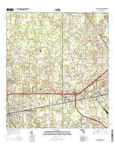
~ Plant City East FL topo map, 1:24000 scale, 7.5 X 7.5 Minute, 2015
Plant City East, Florida, USGS topographic map dated 2015.
Includes geographic coordinates (latitude and longitude). This topographic map is suitable for hiking, camping, and exploring, or framing it as a wall map.
Printed on-demand using high resolution imagery, on heavy weight and acid free paper, or alternatively on a variety of synthetic materials.
Topos available on paper, Waterproof, Poly, or Tyvek. Usually shipping rolled, unless combined with other folded maps in one order.
- Product Number: USGS-8004726
- Free digital map download (high-resolution, GeoPDF): Plant City East, Florida (file size: 29 MB)
- Map Size: please refer to the dimensions of the GeoPDF map above
- Weight (paper map): ca. 55 grams
- Map Type: POD USGS Topographic Map
- Map Series: US Topo
- Map Verison: Current
- Cell ID: 35569
- Datum: North American Datum of 1983
- Map Projection: Transverse Mercator
- Map Cell Name: Plant City East
- Grid size: 7.5 X 7.5 Minute
- Date on map: 2015
- Map Scale: 1:24000
- Geographical region: Florida, United States
Neighboring Maps:
All neighboring USGS topo maps are available for sale online at a variety of scales.
Spatial coverage:
Topo map Plant City East, Florida, covers the geographical area associated the following places:
- South Farmington - Four Bar Estates - Ramblin Oaks - Drew - Mystic Oaks - Washington Park - Evergreen Mobile Home Park - Swindell Road Mobile Home Park - Glendale - Country Villa Mobile Home Court - McDavid Terrace - Terry Park - Oak Dale - Gilchrist - Cauleys Mobile Home Park - Wyatt Acres - Four Seasons - Dell Oaks - Hobby - Hill Crest - Plant City - Midway Groves - Vitelli Acres - Soggy Bottom Acres - Seminole Sand - Mayday Oaks - North Gibson Terrace - Wilder Reserve - Country Aire - Midway Gardens - Pineview - Roseland Park - Ham Oaks - Country Oak Park - Collins Park - Kings Village - Oakmont Mobile Home Park - Shangri La Mobile Home Park - Meadowbrook Mobile Home Park - Rosemont - Stalvey Oaks - Mimosa Park - Bracewell Heights - Bell Ringer Mobile Home Park - Maxwell Acres - Lincoln Park South - Brookers Mobile Home Court - Wilder Oaks - Jones Colony Acres - Shannon Terrace - Daily - Camp T F Addition - Haggard - Pinehurst North - Big Water - Winston - Hibiscus Gardens Mobile Home Park - Gibson Terrace - Elim Mobile Home Park - Deer Creek Hollow - Wiggins - Wilder Park - Gilchrist Heights - Wilder Woods - Lincoln Park East - Swilley Acres - Lincoln Park - Palm Heights - Barlee - Dorene Terrace - Kathleen - Sweats - Futch Place - Mount Enon - Orange Crest - Alabama - East Side - Water Oak - Briarwood Estates Mobile Home Community - Youmans - Bristol Park - Phillips Trail - Lakeland Gardens Mobile Home Park - Cameron Acres - Westbrook - Lee Villa - Colonial Woods - Galloway - Twin Palms Mobile Home Park - Vilma Acres - Gilbertsen Acres - Midway Acres - Strawberry Terrace South - Colonial Village - Marshall Terrace - Blackwater - Futch Acres - Midway - Cherry Park - Old Hickery
- Map Area ID: AREA28.12528-82.125-82
- Northwest corner Lat/Long code: USGSNW28.125-82.125
- Northeast corner Lat/Long code: USGSNE28.125-82
- Southwest corner Lat/Long code: USGSSW28-82.125
- Southeast corner Lat/Long code: USGSSE28-82
- Northern map edge Latitude: 28.125
- Southern map edge Latitude: 28
- Western map edge Longitude: -82.125
- Eastern map edge Longitude: -82


