
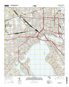
~ Jacksonville FL topo map, 1:24000 scale, 7.5 X 7.5 Minute, 2015
Jacksonville, Florida, USGS topographic map dated 2015.
Includes geographic coordinates (latitude and longitude). This topographic map is suitable for hiking, camping, and exploring, or framing it as a wall map.
Printed on-demand using high resolution imagery, on heavy weight and acid free paper, or alternatively on a variety of synthetic materials.
Topos available on paper, Waterproof, Poly, or Tyvek. Usually shipping rolled, unless combined with other folded maps in one order.
- Product Number: USGS-8003402
- Free digital map download (high-resolution, GeoPDF): Jacksonville, Florida (file size: 26 MB)
- Map Size: please refer to the dimensions of the GeoPDF map above
- Weight (paper map): ca. 55 grams
- Map Type: POD USGS Topographic Map
- Map Series: US Topo
- Map Verison: Current
- Cell ID: 22316
- Datum: North American Datum of 1983
- Map Projection: Transverse Mercator
- Map Cell Name: Jacksonville
- Grid size: 7.5 X 7.5 Minute
- Date on map: 2015
- Map Scale: 1:24000
- Geographical region: Florida, United States
Neighboring Maps:
All neighboring USGS topo maps are available for sale online at a variety of scales.
Spatial coverage:
Topo map Jacksonville, Florida, covers the geographical area associated the following places:
- Longbranch Trailer Park - South Metro - Biltmore - Lakewood - Philips - Englewood - Larsen - Edgewood - Saint Nicholas - Grand Crossing - Pine Oaks Mobile Home Park - Ideal Trailer Park - Ortega Terrace - Southside Mobile Home Park - Phoenix Park - Ortega - Ortega Farms - Lake Shore - Miramar Terrace - Royal Terrace - Springfield - Pickettville - Talleyrand - Gateway Trailer Park - Brentwood - Jacksonville - Avondale - Grand Park - Murray Hill - Pearl Court - Hyde Park - San Marco - Saint Johns Park - Biltmore - Murray Hill - College Park - Riverside - West Jacksonville - San Jose Forest - Ortega Forest - South Jacksonville - Cedar Hills Estates - Brooklyn - Brothers Mobile Home Park - Cedar Hills
- Map Area ID: AREA30.37530.25-81.75-81.625
- Northwest corner Lat/Long code: USGSNW30.375-81.75
- Northeast corner Lat/Long code: USGSNE30.375-81.625
- Southwest corner Lat/Long code: USGSSW30.25-81.75
- Southeast corner Lat/Long code: USGSSE30.25-81.625
- Northern map edge Latitude: 30.375
- Southern map edge Latitude: 30.25
- Western map edge Longitude: -81.75
- Eastern map edge Longitude: -81.625


