
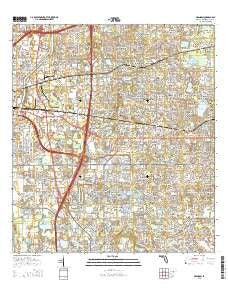
~ Brandon FL topo map, 1:24000 scale, 7.5 X 7.5 Minute, 2015
Brandon, Florida, USGS topographic map dated 2015.
Includes geographic coordinates (latitude and longitude). This topographic map is suitable for hiking, camping, and exploring, or framing it as a wall map.
Printed on-demand using high resolution imagery, on heavy weight and acid free paper, or alternatively on a variety of synthetic materials.
Topos available on paper, Waterproof, Poly, or Tyvek. Usually shipping rolled, unless combined with other folded maps in one order.
- Product Number: USGS-8002095
- Free digital map download (high-resolution, GeoPDF): Brandon, Florida (file size: 34 MB)
- Map Size: please refer to the dimensions of the GeoPDF map above
- Weight (paper map): ca. 55 grams
- Map Type: POD USGS Topographic Map
- Map Series: US Topo
- Map Verison: Current
- Cell ID: 5263
- Datum: North American Datum of 1983
- Map Projection: Transverse Mercator
- Map Cell Name: Brandon
- Grid size: 7.5 X 7.5 Minute
- Date on map: 2015
- Map Scale: 1:24000
- Geographical region: Florida, United States
Neighboring Maps:
All neighboring USGS topo maps are available for sale online at a variety of scales.
Spatial coverage:
Topo map Brandon, Florida, covers the geographical area associated the following places:
- Oak Ridge Terrace - Buffalo Avenue Farms - Tampa Terrace - Sanson Park - Legacy Park - Valrico Lake Estates - Bryan Oaks - Green Meadow Estates - Camelot Woods - Scanlon Country Estates - Orient Park - Raven Oaks - Windhorst Village - Hudsons Haven - Chelsea Manor - Westwood - Sunway - Hillcrest Mobile Estates - Hickory Highlands - Clayton - Kingswood Heights - Valley View Garden Homes - Timber Creek - Providence Oaks - Speedway Park - The Winds - Colony Hill Estates - Pine Lawn Terrace - Countryside Manor - Alexandria Place - Lynwood Park - Scenic Heights - Eden Park - Little Oak Estates - Las Brisas - Oakwood Ravine - Suntree Estates - Hidden Forest - Eleven Mile Hill - Melodie Park - Lakewood Hills - Mango Groves - Goins Terrace - Varn Park - Royal Crest Estates - Oak Valley - Allendale - Hilldale Heights of Brandon - Timber Knoll - Kingsway Gardens - Mango - Pats - Rivergate - Starlite - Random Oaks - Happy Homes - Long Pond - Brandon - Waldrop Estates - Eastlyn - Krycuil Oaks Estates - Brandon Park - Belle Timbre - Brandon Oaks - Sunrise Manor - Valrico Village - Brandontree - Kingsway Oaks - Bell Shoals Gardens - Bloomingdale Villas - Amys Acres - Easy Way - Seffner Park - Wheeler Groves - Paka Estates - Oak Mont Woods - Faulkenburg Heights - Brandon Mobile Estates - Estates at Limona Woods - Highland Ridge - Green Ridge Estates - Wexford Green - Oaks at Valrico - Keebler - Palm River Park - Peppermill at Providence Lakes - Dixie View - Royal Manor - Brandon Oak Grove Estates - Oak Glen - Southern Oaks Grove - Causeway Manor - Orangewood - Perrywood - Lazy Lane Estates - Bates - Bryant Terrace - Oakwood Heights - Winston Manor - Brandon Forest
- Map Area ID: AREA2827.875-82.375-82.25
- Northwest corner Lat/Long code: USGSNW28-82.375
- Northeast corner Lat/Long code: USGSNE28-82.25
- Southwest corner Lat/Long code: USGSSW27.875-82.375
- Southeast corner Lat/Long code: USGSSE27.875-82.25
- Northern map edge Latitude: 28
- Southern map edge Latitude: 27.875
- Western map edge Longitude: -82.375
- Eastern map edge Longitude: -82.25


