
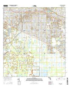
~ Alva SW FL topo map, 1:24000 scale, 7.5 X 7.5 Minute, 2015
Alva SW, Florida, USGS topographic map dated 2015.
Includes geographic coordinates (latitude and longitude). This topographic map is suitable for hiking, camping, and exploring, or framing it as a wall map.
Printed on-demand using high resolution imagery, on heavy weight and acid free paper, or alternatively on a variety of synthetic materials.
Topos available on paper, Waterproof, Poly, or Tyvek. Usually shipping rolled, unless combined with other folded maps in one order.
- Product Number: USGS-8001929
- Free digital map download (high-resolution, GeoPDF): Alva SW, Florida (file size: 31 MB)
- Map Size: please refer to the dimensions of the GeoPDF map above
- Weight (paper map): ca. 55 grams
- Map Type: POD USGS Topographic Map
- Map Series: US Topo
- Map Verison: Current
- Cell ID: 791
- Datum: North American Datum of 1983
- Map Projection: Transverse Mercator
- Map Cell Name: Alva SW
- Grid size: 7.5 X 7.5 Minute
- Date on map: 2015
- Map Scale: 1:24000
- Geographical region: Florida, United States
Neighboring Maps:
All neighboring USGS topo maps are available for sale online at a variety of scales.
Spatial coverage:
Topo map Alva SW, Florida, covers the geographical area associated the following places:
- Lehigh Regional Medical Center - Halfway Pond - Caloosahatchee Forestry Center - Lehigh Acres Christian Academy - Lehigh Acres Census Designated Place - Lake Camille Shopping Center - Able Canal - Lauderhills Golf Course - Lee Memorial Garden Cemetery - Lehigh Elementary School - Gateway Census Designated Place - First Church of Christ Scientist - Lee County Sheriff's Office Bravo East District - Las Colinas Golf Course - Lehigh Acres Post Office - Lee Boulevard Shopping Center - Lehigh Acres Division - Lehigh Memorial Park - Lee Boulevard Baptist Church - Homestead Shopping Center - Lehigh Acres Middle School - Lehigh Acres Fire Control and Rescue District Station 102 - Lehigh Acres Fire Control and Rescue District Station 103 - Korean Assembly of God Church of Fort Myers - Sunshine Plaza and Mall - Christ United Methodist Church of Lehigh Acres - Lehigh Acres Church of the Nazarene - Trinity Baptist Chapel - Lehigh Acres Fire Control and Rescue Station 104
- Map Area ID: AREA26.62526.5-81.75-81.625
- Northwest corner Lat/Long code: USGSNW26.625-81.75
- Northeast corner Lat/Long code: USGSNE26.625-81.625
- Southwest corner Lat/Long code: USGSSW26.5-81.75
- Southeast corner Lat/Long code: USGSSE26.5-81.625
- Northern map edge Latitude: 26.625
- Southern map edge Latitude: 26.5
- Western map edge Longitude: -81.75
- Eastern map edge Longitude: -81.625


