
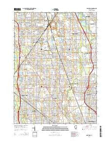
~ Park Ridge IL topo map, 1:24000 scale, 7.5 X 7.5 Minute, 2015
Park Ridge, Illinois, USGS topographic map dated 2015.
Includes geographic coordinates (latitude and longitude). This topographic map is suitable for hiking, camping, and exploring, or framing it as a wall map.
Printed on-demand using high resolution imagery, on heavy weight and acid free paper, or alternatively on a variety of synthetic materials.
Topos available on paper, Waterproof, Poly, or Tyvek. Usually shipping rolled, unless combined with other folded maps in one order.
- Product Number: USGS-7999409
- Free digital map download (high-resolution, GeoPDF): Park Ridge, Illinois (file size: 26 MB)
- Map Size: please refer to the dimensions of the GeoPDF map above
- Weight (paper map): ca. 55 grams
- Map Type: POD USGS Topographic Map
- Map Series: US Topo
- Map Verison: Current
- Cell ID: 34230
- Datum: North American Datum of 1983
- Map Projection: Transverse Mercator
- Map Cell Name: Park Ridge
- Grid size: 7.5 X 7.5 Minute
- Date on map: 2015
- Map Scale: 1:24000
- Geographical region: Illinois, United States
Neighboring Maps:
All neighboring USGS topo maps are available for sale online at a variety of scales.
Spatial coverage:
Topo map Park Ridge, Illinois, covers the geographical area associated the following places:
- Porters Glenview Subdivision - Floral Terrace Estates - Park Ridge - Orchard Subdivision - Willow Creek - Homefinders - Willowbrook Acres - Willow Woods - Covenant Village - Porter Subdivision - Kinswept Subdivision - Glenview - Northbrook Greens - Kimberleigh - Solar Grove - Glenbrook Acres West - Wahl's Subdivision - Morton Grove - Park Place Estates of Northbrook - Braeside Subdivision - The Courts - The Commons - Northbrook Acres - Mallard Creek - Driftwood - Northbrook West - Stonebrook East - Northfield - Florian - Cobblewood - La Salceda Subdivision - Tall Oaks Subdivision - Stonehedge Glen - Anetsberger's Subdivision - DorothyStirling Estates - Michealsen Subdivision - Techny (historical) - Brockdale Manor - Sunset Fields - Citation Lake - Arrowhead - Summerhill - Maryland Subdivision - Royal Ridge - Highland Woods - Stonebrook - Woodmere Subdivision - Skiersch's Subdivision - The Willows - Westfield - Schultz's Subdivision - Rozenow's Subdivision - Indian Ridge - Windham Manor - Pine Grove - Birch Pond - Siemar Subdivision - Whisperwoods of Northbrook - Levelview Acres - Golf - Jessical Lane Subdivision - The Grove - Stone Hedge - Stone Hedge Manor - Volte Court - Sunset Court - Niles - Meadow Green - Dorothy Stirling Subdivision - Northbrook Park - Willow Cove - Fox Hedge - La Vingnes Acres - Southbridge Commons - Cozy Corner - Deercrest Estates - Landwehr Estates - Donovan Glen Subdivision - Fox Run - Heathercrest - Villas West - Ramsgate South - Loveland's Subdivision - Dehne's Subdivision - Oliver Lane Subdivision - Windham - Willows North - Stonegate - Royal Court - Northway - Highcrest - Cedarbrook Court - Hansen Subdivision
- Map Area ID: AREA42.12542-87.875-87.75
- Northwest corner Lat/Long code: USGSNW42.125-87.875
- Northeast corner Lat/Long code: USGSNE42.125-87.75
- Southwest corner Lat/Long code: USGSSW42-87.875
- Southeast corner Lat/Long code: USGSSE42-87.75
- Northern map edge Latitude: 42.125
- Southern map edge Latitude: 42
- Western map edge Longitude: -87.875
- Eastern map edge Longitude: -87.75


