
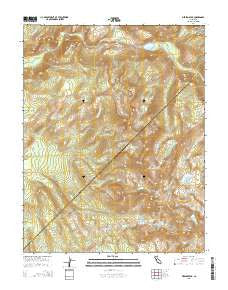
~ Merced Peak CA topo map, 1:24000 scale, 7.5 X 7.5 Minute, 2015
Merced Peak, California, USGS topographic map dated 2015.
Includes geographic coordinates (latitude and longitude). This topographic map is suitable for hiking, camping, and exploring, or framing it as a wall map.
Printed on-demand using high resolution imagery, on heavy weight and acid free paper, or alternatively on a variety of synthetic materials.
Topos available on paper, Waterproof, Poly, or Tyvek. Usually shipping rolled, unless combined with other folded maps in one order.
- Product Number: USGS-7980792
- Free digital map download (high-resolution, GeoPDF): Merced Peak, California (file size: 29 MB)
- Map Size: please refer to the dimensions of the GeoPDF map above
- Weight (paper map): ca. 55 grams
- Map Type: POD USGS Topographic Map
- Map Series: US Topo
- Map Verison: Current
- Cell ID: 28805
- Datum: North American Datum of 1983
- Map Projection: Transverse Mercator
- Map Cell Name: Merced Peak
- Grid size: 7.5 X 7.5 Minute
- Date on map: 2015
- Map Scale: 1:24000
- Geographical region: California, United States
Neighboring Maps:
All neighboring USGS topo maps are available for sale online at a variety of scales.
Spatial coverage:
Topo map Merced Peak, California, covers the geographical area associated the following places:
- Merced Lake High Sierra Camp - Lower Merced Pass Lake - Red Peak - Merced Lake Ranger Station - Ottoway Lakes - Clark Range - Ottoway Creek - Cascade Cliffs - Gray Creek - Quartzite Peak - Mount Clark - Merced Peak - Red Devil Lake - Gray Peak - Lower Ottoway Lake - Grayling Lake - Bunnell Cascade - Lost Valley - Ottoway Peak - Bunnell Point - Echo Valley - Merced Lake - Moraine Dome - Echo Creek - Upper Ottoway Lake - Adair Lake - Obelisk Lake - Edna Lake - Fletcher Creek - Clark Canyon - Red Peak Pass - Gray Peak Fork - Lewis Creek - Bunnell Cliff
- Map Area ID: AREA37.7537.625-119.5-119.375
- Northwest corner Lat/Long code: USGSNW37.75-119.5
- Northeast corner Lat/Long code: USGSNE37.75-119.375
- Southwest corner Lat/Long code: USGSSW37.625-119.5
- Southeast corner Lat/Long code: USGSSE37.625-119.375
- Northern map edge Latitude: 37.75
- Southern map edge Latitude: 37.625
- Western map edge Longitude: -119.5
- Eastern map edge Longitude: -119.375


