
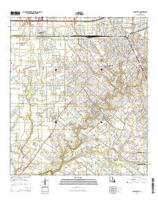
~ Lafayette LA topo map, 1:24000 scale, 7.5 X 7.5 Minute, 2015
Lafayette, Louisiana, USGS topographic map dated 2015.
Includes geographic coordinates (latitude and longitude). This topographic map is suitable for hiking, camping, and exploring, or framing it as a wall map.
Printed on-demand using high resolution imagery, on heavy weight and acid free paper, or alternatively on a variety of synthetic materials.
Topos available on paper, Waterproof, Poly, or Tyvek. Usually shipping rolled, unless combined with other folded maps in one order.
- Product Number: USGS-7974159
- Free digital map download (high-resolution, GeoPDF): Lafayette, Louisiana (file size: 29 MB)
- Map Size: please refer to the dimensions of the GeoPDF map above
- Weight (paper map): ca. 55 grams
- Map Type: POD USGS Topographic Map
- Map Series: US Topo
- Map Verison: Current
- Cell ID: 24246
- Datum: North American Datum of 1983
- Map Projection: Transverse Mercator
- Map Cell Name: Lafayette
- Grid size: 7.5 X 7.5 Minute
- Date on map: 2015
- Map Scale: 1:24000
- Geographical region: Louisiana, United States
Neighboring Maps:
All neighboring USGS topo maps are available for sale online at a variety of scales.
Spatial coverage:
Topo map Lafayette, Louisiana, covers the geographical area associated the following places:
- Acadian Acres Mobile Home Park - West Gate Trailer Park - Village Park Mobile Estate - Holiday Mobile Home Villa Park - Broadmoor - Norberts Golden Gate Mobile Home Park - Smittys Mobile Home Park - Pecan Acres Mobile Home Park - Arbolada Addition - Northgrove Mobile Home Park - Chester Domingue Mobile Home Park - Tecos Mobile Home Park - Summerwood Mobile Home Community - Willow Springs Mobile Home Park - Oak Park Estates Mobile Home Park - Bendel Gardens - Carroll Ann Mobile Home Park - Lafayette - G and R Mobile Park - Southern Consumer Mobile Home Park - Lantier Mobile Home Park - Country Aire Mobile Home Park - Mobile Home Acres - Scott - Mr B's Mobile Home Park - Whittington Heights Mobile Home Park - Shorts Mobile Estates - Landall Mobile Estates - Credeur Mobile Home Park - Warren Landry Mobile Home Park - Thibodeaux Mobile Home Park - Brambles Mobile Home Park
- Map Area ID: AREA30.2530.125-92.125-92
- Northwest corner Lat/Long code: USGSNW30.25-92.125
- Northeast corner Lat/Long code: USGSNE30.25-92
- Southwest corner Lat/Long code: USGSSW30.125-92.125
- Southeast corner Lat/Long code: USGSSE30.125-92
- Northern map edge Latitude: 30.25
- Southern map edge Latitude: 30.125
- Western map edge Longitude: -92.125
- Eastern map edge Longitude: -92


