
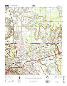
~ Bossier City LA topo map, 1:24000 scale, 7.5 X 7.5 Minute, 2015
Bossier City, Louisiana, USGS topographic map dated 2015.
Includes geographic coordinates (latitude and longitude). This topographic map is suitable for hiking, camping, and exploring, or framing it as a wall map.
Printed on-demand using high resolution imagery, on heavy weight and acid free paper, or alternatively on a variety of synthetic materials.
Topos available on paper, Waterproof, Poly, or Tyvek. Usually shipping rolled, unless combined with other folded maps in one order.
- Product Number: USGS-7971754
- Free digital map download (high-resolution, GeoPDF): Bossier City, Louisiana (file size: 27 MB)
- Map Size: please refer to the dimensions of the GeoPDF map above
- Weight (paper map): ca. 55 grams
- Map Type: POD USGS Topographic Map
- Map Series: US Topo
- Map Verison: Current
- Cell ID: 4924
- Datum: North American Datum of 1983
- Map Projection: Transverse Mercator
- Map Cell Name: Bossier City
- Grid size: 7.5 X 7.5 Minute
- Date on map: 2015
- Map Scale: 1:24000
- Geographical region: Louisiana, United States
Neighboring Maps:
All neighboring USGS topo maps are available for sale online at a variety of scales.
Spatial coverage:
Topo map Bossier City, Louisiana, covers the geographical area associated the following places:
- Southern Terrace - Brownlee - Coleman Park - Ferguson - Vanceville - Cloverdale - Glendale - Bossier City - Carriage Oaks - Parkland Village - Whitehurst - Swan Lake - Airline Park Estates - Brookhaven Estates - Fosters - Green Acres - Hinkle - Greenacres Place - Brownlee Estates - Honore - Waller - Meadowview Park
- Map Area ID: AREA32.62532.5-93.75-93.625
- Northwest corner Lat/Long code: USGSNW32.625-93.75
- Northeast corner Lat/Long code: USGSNE32.625-93.625
- Southwest corner Lat/Long code: USGSSW32.5-93.75
- Southeast corner Lat/Long code: USGSSE32.5-93.625
- Northern map edge Latitude: 32.625
- Southern map edge Latitude: 32.5
- Western map edge Longitude: -93.75
- Eastern map edge Longitude: -93.625


