
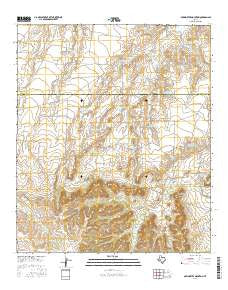
~ McWhorter Mountain TX topo map, 1:24000 scale, 7.5 X 7.5 Minute, 2016
McWhorter Mountain, Texas, USGS topographic map dated 2016.
Includes geographic coordinates (latitude and longitude). This topographic map is suitable for hiking, camping, and exploring, or framing it as a wall map.
Printed on-demand using high resolution imagery, on heavy weight and acid free paper, or alternatively on a variety of synthetic materials.
Topos available on paper, Waterproof, Poly, or Tyvek. Usually shipping rolled, unless combined with other folded maps in one order.
- Product Number: USGS-7938072
- Free digital map download (high-resolution, GeoPDF): McWhorter Mountain, Texas (file size: 26 MB)
- Map Size: please refer to the dimensions of the GeoPDF map above
- Weight (paper map): ca. 55 grams
- Map Type: POD USGS Topographic Map
- Map Series: US Topo
- Map Verison: Current
- Cell ID: 28540
- Datum: North American Datum of 1983
- Map Projection: Transverse Mercator
- Map Cell Name: McWhorter Mountain
- Grid size: 7.5 X 7.5 Minute
- Date on map: 2016
- Map Scale: 1:24000
- Geographical region: Texas, United States
Neighboring Maps:
All neighboring USGS topo maps are available for sale online at a variety of scales.
Spatial coverage:
Topo map McWhorter Mountain, Texas, covers the geographical area associated the following places:
- Northeast Seamen Tank - Divide Windmill - Middle Tank - Buck Tank - Double Tank - Northwest Seamen Tank - Big Red Tank - New Boatright Tank - Usg Number One Tank - Willow Tank - Four Section Tank - Five Section Tank - Corral Tank - Mountain Tank - East Windmill - Willow Net Tank - McWhorter Mountain - Dempster Windmill - Northwest Antelope Tank - John Tang Tank - Horse Pasture Tank - Old Boatright Tank - Antelope Creek - Limekin Tank - Antelope Tank - Caliche Tank - Middle Seamen Tank - Little Willow Creek - Southeast Bull Tank - Northwest McWhorter Tank - John W Tank - McWhorter Mountain Tank - Northwest Boatright Tank - Powell Sheep Camp - The Gap - New McWhorter Tank - Northeast Boatright Tank - Bull Tank - Southwest Bull Tank - Southwest Antelope Tank - Little Water Tank
- Map Area ID: AREA32.12532-101-100.875
- Northwest corner Lat/Long code: USGSNW32.125-101
- Northeast corner Lat/Long code: USGSNE32.125-100.875
- Southwest corner Lat/Long code: USGSSW32-101
- Southeast corner Lat/Long code: USGSSE32-100.875
- Northern map edge Latitude: 32.125
- Southern map edge Latitude: 32
- Western map edge Longitude: -101
- Eastern map edge Longitude: -100.875


