
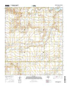
~ Gunsight Draw SE TX topo map, 1:24000 scale, 7.5 X 7.5 Minute, 2016
Gunsight Draw SE, Texas, USGS topographic map dated 2016.
Includes geographic coordinates (latitude and longitude). This topographic map is suitable for hiking, camping, and exploring, or framing it as a wall map.
Printed on-demand using high resolution imagery, on heavy weight and acid free paper, or alternatively on a variety of synthetic materials.
Topos available on paper, Waterproof, Poly, or Tyvek. Usually shipping rolled, unless combined with other folded maps in one order.
- Product Number: USGS-7931117
- Free digital map download (high-resolution, GeoPDF): Gunsight Draw SE, Texas (file size: 23 MB)
- Map Size: please refer to the dimensions of the GeoPDF map above
- Weight (paper map): ca. 55 grams
- Map Type: POD USGS Topographic Map
- Map Series: US Topo
- Map Verison: Current
- Cell ID: 18763
- Datum: North American Datum of 1983
- Map Projection: Transverse Mercator
- Map Cell Name: Gunsight Draw SE
- Grid size: 7.5 X 7.5 Minute
- Date on map: 2016
- Map Scale: 1:24000
- Geographical region: Texas, United States
Neighboring Maps:
All neighboring USGS topo maps are available for sale online at a variety of scales.
Spatial coverage:
Topo map Gunsight Draw SE, Texas, covers the geographical area associated the following places:
- Wolf Tank - Hobo Oil Field - Hullem Creek - Bull Pasture Tank - Hillside Tank - Red Bluffs - Boedecker Tank - South Pasture Tanks - Hackberry Draw - Double Tanks - Round Tank - Flat Tank - Whitaker Field Tank - Fairview Cemetery - Cedar Point - North Holley Tank - Creek Tank - South Holley Tank - Little Red Tank - Rutherford Tank - Reineke Vincent Oil Field - Mother-in-Law Tank - Road Tank - East Vealmoor Oil Field - Simer Lake Dam - Horseshoe Tank - Sand Tank - Hudson Tank - Sand Rock Tank - Simer Lake - Bush and Tiller Tank - Wildcat Tank
- Map Area ID: AREA32.62532.5-101.375-101.25
- Northwest corner Lat/Long code: USGSNW32.625-101.375
- Northeast corner Lat/Long code: USGSNE32.625-101.25
- Southwest corner Lat/Long code: USGSSW32.5-101.375
- Southeast corner Lat/Long code: USGSSE32.5-101.25
- Northern map edge Latitude: 32.625
- Southern map edge Latitude: 32.5
- Western map edge Longitude: -101.375
- Eastern map edge Longitude: -101.25


