
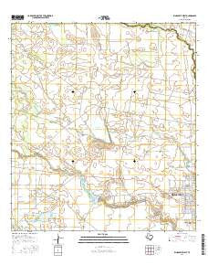
~ Kingsville West TX topo map, 1:24000 scale, 7.5 X 7.5 Minute, 2016
Kingsville West, Texas, USGS topographic map dated 2016.
Includes geographic coordinates (latitude and longitude). This topographic map is suitable for hiking, camping, and exploring, or framing it as a wall map.
Printed on-demand using high resolution imagery, on heavy weight and acid free paper, or alternatively on a variety of synthetic materials.
Topos available on paper, Waterproof, Poly, or Tyvek. Usually shipping rolled, unless combined with other folded maps in one order.
- Product Number: USGS-7871160
- Free digital map download (high-resolution, GeoPDF): Kingsville West, Texas (file size: 25 MB)
- Map Size: please refer to the dimensions of the GeoPDF map above
- Weight (paper map): ca. 55 grams
- Map Type: POD USGS Topographic Map
- Map Series: US Topo
- Map Verison: Current
- Cell ID: 23672
- Datum: North American Datum of 1983
- Map Projection: Transverse Mercator
- Map Cell Name: Kingsville West
- Grid size: 7.5 X 7.5 Minute
- Date on map: 2016
- Map Scale: 1:24000
- Geographical region: Texas, United States
Neighboring Maps:
All neighboring USGS topo maps are available for sale online at a variety of scales.
Spatial coverage:
Topo map Kingsville West, Texas, covers the geographical area associated the following places:
- Kingsville Fire Department Station 2 - Stratton Camp Well - KNGV-FM (Kingsville) - Douglas Well - University Baptist Church - Muerto Pens - West Stratton Oil Field - King Ranch Dam Number 6 - Palo Lobo Windmill - Tulosa Windmill - Carta Blanca Well - Tranquitas Lake - King Ranch Dam Number 3 - Reservoir Number 3 - Stratton Pumping Station - Puertos Windmill - Sens - Ible Care - Harrel School - Upper Little Windmill - Oliver Till Airport (historical) - Santo Gertrudis Memorial Cemetery - Los Indios Lake - Mopac Field - Miguel Windmill - Cerritos Windmill - Memorial Middle School - Texas A and I University - Tulosa Lake - Reservoir Number 5 - Ogados Lake - Matanza Windmill - King Ranch - King Ranch Dam Number 5 - Harrel Elementary School - Reservoir Number 6 - Santa Gertrudis Elementary School - Posta Water Hole - Academy High School - Mota Huisache Windmill - Stratton Oil Field - Chamberlain Cemetery - KTAI-FM (Kingsville) - Arredondo Windmill - Martin Windmill
- Map Area ID: AREA27.62527.5-98-97.875
- Northwest corner Lat/Long code: USGSNW27.625-98
- Northeast corner Lat/Long code: USGSNE27.625-97.875
- Southwest corner Lat/Long code: USGSSW27.5-98
- Southeast corner Lat/Long code: USGSSE27.5-97.875
- Northern map edge Latitude: 27.625
- Southern map edge Latitude: 27.5
- Western map edge Longitude: -98
- Eastern map edge Longitude: -97.875


