
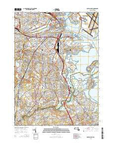
~ Boston South MA topo map, 1:24000 scale, 7.5 X 7.5 Minute, 2015
Boston South, Massachusetts, USGS topographic map dated 2015.
Includes geographic coordinates (latitude and longitude). This topographic map is suitable for hiking, camping, and exploring, or framing it as a wall map.
Printed on-demand using high resolution imagery, on heavy weight and acid free paper, or alternatively on a variety of synthetic materials.
Topos available on paper, Waterproof, Poly, or Tyvek. Usually shipping rolled, unless combined with other folded maps in one order.
- Product Number: USGS-7842429
- Free digital map download (high-resolution, GeoPDF): Boston South, Massachusetts (file size: 26 MB)
- Map Size: please refer to the dimensions of the GeoPDF map above
- Weight (paper map): ca. 55 grams
- Map Type: POD USGS Topographic Map
- Map Series: US Topo
- Map Verison: Current
- Cell ID: 4932
- Datum: North American Datum of 1983
- Map Projection: Transverse Mercator
- Map Cell Name: Boston South
- Grid size: 7.5 X 7.5 Minute
- Date on map: 2015
- Map Scale: 1:24000
- Geographical region: Massachusetts, United States
Neighboring Maps:
All neighboring USGS topo maps are available for sale online at a variety of scales.
Spatial coverage:
Topo map Boston South, Massachusetts, covers the geographical area associated the following places:
- Neponset - Quincy - Dock Square - Milton Center - City Point - Mount Hope - West Quincy - Uphams Corner - Bay Village - Squantum - Milton Upper Mills - Brookline Village - Fort Winthrop (historical) - Cambridgeport - Wollaston - Brookline - East Milton - Mount Bowdoin - Coolidge Corner - Forbes Wharf - Forest Hills - Longwood Station - Dorchester - Fields Corner - Mattapan - Montclair - Beacon Hill - Ashmont - New Squantum - Mount Ida - Atlantic - Roxbury Crossing - Cedar Grove - Forest Hills - South Boston - Roslindale - Savin Hill - North End - Roxbury - Lower Mills - Downtown Crossing - Jeffries Point - Back Bay - Grove Hall - Jamaica Plain - North Quincy - Fairmount - East Cambridge - Norfolk Downs - Meeting House Hill - Dorchester Heights - Fort Independence - Milton Village - Milton Hill - Clarendon Hills - Boston - Hyde Park - Dorchester Center
- Map Area ID: AREA42.37542.25-71.125-71
- Northwest corner Lat/Long code: USGSNW42.375-71.125
- Northeast corner Lat/Long code: USGSNE42.375-71
- Southwest corner Lat/Long code: USGSSW42.25-71.125
- Southeast corner Lat/Long code: USGSSE42.25-71
- Northern map edge Latitude: 42.375
- Southern map edge Latitude: 42.25
- Western map edge Longitude: -71.125
- Eastern map edge Longitude: -71


