
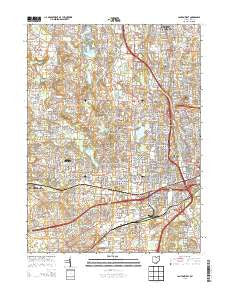
~ Canton West OH topo map, 1:24000 scale, 7.5 X 7.5 Minute, Historical, 2013
Canton West, Ohio, USGS topographic map dated 2013.
Includes geographic coordinates (latitude and longitude). This topographic map is suitable for hiking, camping, and exploring, or framing it as a wall map.
Printed on-demand using high resolution imagery, on heavy weight and acid free paper, or alternatively on a variety of synthetic materials.
Topos available on paper, Waterproof, Poly, or Tyvek. Usually shipping rolled, unless combined with other folded maps in one order.
- Product Number: USGS-7821262
- Free digital map download (high-resolution, GeoPDF): Canton West, Ohio (file size: 37 MB)
- Map Size: please refer to the dimensions of the GeoPDF map above
- Weight (paper map): ca. 55 grams
- Map Type: POD USGS Topographic Map
- Map Series: US Topo
- Map Verison: Historical
- Cell ID: 7123
- Datum: North American Datum of 1983
- Map Projection: Transverse Mercator
- Map Cell Name: Canton West
- Grid size: 7.5 X 7.5 Minute
- Date on map: 2013
- Map Scale: 1:24000
- Geographical region: Ohio, United States
Neighboring Maps:
All neighboring USGS topo maps are available for sale online at a variety of scales.
Spatial coverage:
Topo map Canton West, Ohio, covers the geographical area associated the following places:
- Carie Hill Estates - Indianola Estates - Lake Cable - Whipple Heights - Lake View Heights - Monterey Heights - Colonial Hills - Cloverdale - Parkridge - Whittier Park - South Haven Mobile Park - Lincoln Heights - Terrace Mobile Park - Augusta Lakes - Lakeside Heights - Wexford - Fulton Heights - Industrial Heights - Canton - Bramblecrest - Banker Heights - Mount Marie Heights - Sunny Acres Mobile Park - Meyers Lake - The Knolls - Harter Heights - Lakeview Terrace - Crescent Gardens - Hills and Dales - Avondale - Belvidere - Grey Ridge Estates - Reedurban - Melody Mobile Home Park - Whispering Oaks - Bishop Meadows - Sweetbriar - Edgefield - Edgewood Park - Ridgedale - Sun Valley Mobile Home Park - Deluxe Mobile Home Park - Canton Gardens - West Manor Mobile Home Park - Grove Mill - Plymouth Knoll - Oak Manor - Westview - Westland Park - Orchard Acres - Ingold Heights - Richville - Perry Heights - West Manor - Mount Vernon - Lakeview Heights - Gambrinus - Trailer City - Edmeyer Park - Skyline Hills - Genoa
- Map Area ID: AREA40.87540.75-81.5-81.375
- Northwest corner Lat/Long code: USGSNW40.875-81.5
- Northeast corner Lat/Long code: USGSNE40.875-81.375
- Southwest corner Lat/Long code: USGSSW40.75-81.5
- Southeast corner Lat/Long code: USGSSE40.75-81.375
- Northern map edge Latitude: 40.875
- Southern map edge Latitude: 40.75
- Western map edge Longitude: -81.5
- Eastern map edge Longitude: -81.375


