
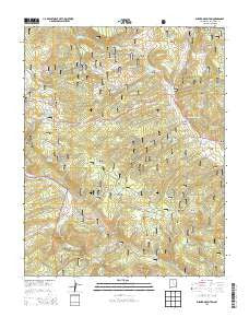
~ Burned Mountain NM topo map, 1:24000 scale, 7.5 X 7.5 Minute, Historical, 2013
Burned Mountain, New Mexico, USGS topographic map dated 2013.
Includes geographic coordinates (latitude and longitude). This topographic map is suitable for hiking, camping, and exploring, or framing it as a wall map.
Printed on-demand using high resolution imagery, on heavy weight and acid free paper, or alternatively on a variety of synthetic materials.
Topos available on paper, Waterproof, Poly, or Tyvek. Usually shipping rolled, unless combined with other folded maps in one order.
- Product Number: USGS-7791019
- Free digital map download (high-resolution, GeoPDF): Burned Mountain, New Mexico (file size: 36 MB)
- Map Size: please refer to the dimensions of the GeoPDF map above
- Weight (paper map): ca. 55 grams
- Map Type: POD USGS Topographic Map
- Map Series: US Topo
- Map Verison: Historical
- Cell ID: 6290
- Datum: North American Datum of 1983
- Map Projection: Transverse Mercator
- Map Cell Name: Burned Mountain
- Grid size: 7.5 X 7.5 Minute
- Date on map: 2013
- Map Scale: 1:24000
- Geographical region: New Mexico, United States
Neighboring Maps:
All neighboring USGS topo maps are available for sale online at a variety of scales.
Spatial coverage:
Topo map Burned Mountain, New Mexico, covers the geographical area associated the following places:
- Moeller Spring - Rinker Lake - Jim Jim Prospect - Royal Purple Group - Sardine - Ten Better Group Mine - Walker Prospect - Inner Mountain Prospect - Juvinile Prospect - Bone Ranch - Kay Tee Prospect - Last Dollar Mine - Lower Flat Placer - Vallecitos Division - Sullivan Park - Middle Canyon Tank - Willow Tank - Deer Trail Creek - Maquinita Canyon - Wedge Prospect - Black Copper Prospect - Little Tusas Creek - Horseshoe Claim - Butterfly Spring - War Eagle Prospect - Beehive Tank - Hummer Prospect - Hornet Group Mine - Mary Elizabeth Prospect - Jawbone Mine - Miners Tank - Middle Canyon - Tusas Mountain - Whale - Hopewell Dam - Mary E Steele Mine - Deer Park - Buckhorn Canyon - Snow Flake Prospect - Jumbo Prospect - Ridge Tank - Black Hawk Claim - Amos Tank - Royal Tank - Jaroso Creek - Hopewell Lake Campground - Union Lode - Burned Mountain - King Richard Prospect - Loyd Tank - El Vallecito Ranch - Silent Friend Group Mine - J O L - Moeller Tank - Espinosa Tank - Deer Tank - Burned Mountain Tank - Duran Canyon - Cañada Jarosita - Rubicon Prospect - Independence Claim - Merrimac Group Mine - Deer Park Tank - Southern Cross Prospect - Whale Group Mine - Willow Gulch - Tusas Ridge - Quartzite Peak - Hoover Number 2 Mine - Strawberry Mine - Schley Prospect - Rock Creek - Yolanda Spring - Spring Creek Tank - Lexington Lode - Espinosa Canyon - Hopewell Ridge - Mayflower Group - Sunrise Prospect - Hoover Number 3 Mine - Roybals Tank - Duran Tank - Sullivan Tank - Jawbone Mountain - Placer Creek - Cunningham Tank - Turkey Lake - Midnight Mine - Last Hope Claim - Asiatic Group - Hopewell Lake - Snow Course Tank - Tusas Uranium Prospects - Grant Corral
- Map Area ID: AREA36.7536.625-106.25-106.125
- Northwest corner Lat/Long code: USGSNW36.75-106.25
- Northeast corner Lat/Long code: USGSNE36.75-106.125
- Southwest corner Lat/Long code: USGSSW36.625-106.25
- Southeast corner Lat/Long code: USGSSE36.625-106.125
- Northern map edge Latitude: 36.75
- Southern map edge Latitude: 36.625
- Western map edge Longitude: -106.25
- Eastern map edge Longitude: -106.125


