
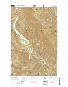
~ Pond Peak ID topo map, 1:24000 scale, 7.5 X 7.5 Minute, Current, 2013
Pond Peak, Idaho, USGS topographic map dated 2013.
Includes geographic coordinates (latitude and longitude). This topographic map is suitable for hiking, camping, and exploring, or framing it as a wall map.
Printed on-demand using high resolution imagery, on heavy weight and acid free paper, or alternatively on a variety of synthetic materials.
Topos available on paper, Waterproof, Poly, or Tyvek. Usually shipping rolled, unless combined with other folded maps in one order.
- Product Number: USGS-7752660
- Free digital map download (high-resolution, GeoPDF): Pond Peak, Idaho (file size: 33 MB)
- Map Size: please refer to the dimensions of the GeoPDF map above
- Weight (paper map): ca. 55 grams
- Map Type: POD USGS Topographic Map
- Map Series: US Topo
- Map Verison: Current
- Cell ID: 35943
- Datum: North American Datum of 1983
- Map Projection: Transverse Mercator
- Map Cell Name: Pond Peak
- Grid size: 7.5 X 7.5 Minute
- Date on map: 2013
- Map Scale: 1:24000
- Geographical region: Idaho, United States
Neighboring Maps:
All neighboring USGS topo maps are available for sale online at a variety of scales.
Spatial coverage:
Topo map Pond Peak, Idaho, covers the geographical area associated the following places:
- Valitons Creek - President Creek - Long Pool - Beetle Creek - Teddy Creek - Svee Creek - Lion Creek - Cardinal Creek - Little Lost Fork - Bruce Creek - Ulm Creek - Emery Creek - Fern Falls - Big Hank Campground - Shoshone Range - Ash Creek - Downey Creek - Big Hank Creek - Cinnamon Creek - Rock City Cabin (historical) - Brett Creek - Ferguson Creek - Burnt Hill - Rock City Pond Peak Trail - Tourist Creek - Guard Peak - Little Canyon Creek - Miners Creek - Wilson Creek - Murray Division - Sentinel Peak - Tent Creek - Little Guard Peak Lookout - Bennett Creek - North Grizzly Creek - Devils Elbow Campground - Bennett Peak - Swift Creek - Big Hank Meadow - Downey Peak - Gold Creek - Stony Creek - Little Guard Peak - Yellow Dog Creek - Shadow Falls - Sentinel Creek - Big Pool - Debbs Creek - Flat Creek - Little Sentinel Peak - Nowhere Creek - Morris Creek - Pond Peak - Taft Creek
- Map Area ID: AREA47.87547.75-116.125-116
- Northwest corner Lat/Long code: USGSNW47.875-116.125
- Northeast corner Lat/Long code: USGSNE47.875-116
- Southwest corner Lat/Long code: USGSSW47.75-116.125
- Southeast corner Lat/Long code: USGSSE47.75-116
- Northern map edge Latitude: 47.875
- Southern map edge Latitude: 47.75
- Western map edge Longitude: -116.125
- Eastern map edge Longitude: -116


