
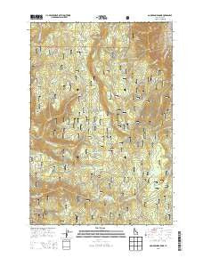
~ Goodwin Meadows ID topo map, 1:24000 scale, 7.5 X 7.5 Minute, Current, 2013
Goodwin Meadows, Idaho, USGS topographic map dated 2013.
Includes geographic coordinates (latitude and longitude). This topographic map is suitable for hiking, camping, and exploring, or framing it as a wall map.
Printed on-demand using high resolution imagery, on heavy weight and acid free paper, or alternatively on a variety of synthetic materials.
Topos available on paper, Waterproof, Poly, or Tyvek. Usually shipping rolled, unless combined with other folded maps in one order.
- Product Number: USGS-7732871
- Free digital map download (high-resolution, GeoPDF): Goodwin Meadows, Idaho (file size: 34 MB)
- Map Size: please refer to the dimensions of the GeoPDF map above
- Weight (paper map): ca. 55 grams
- Map Type: POD USGS Topographic Map
- Map Series: US Topo
- Map Verison: Current
- Cell ID: 70211
- Datum: North American Datum of 1983
- Map Projection: Transverse Mercator
- Map Cell Name: Goodwin Meadows
- Grid size: 7.5 X 7.5 Minute
- Date on map: 2013
- Map Scale: 1:24000
- Geographical region: Idaho, United States
Neighboring Maps:
All neighboring USGS topo maps are available for sale online at a variety of scales.
Spatial coverage:
Topo map Goodwin Meadows, Idaho, covers the geographical area associated the following places:
- Earthquake Creek - Twin Cabins Creek - Goose Creek Point - Fish Creek Recreation Area - Goodwin Creek - East Fork Bully Creek - Corduroy Creek - Cove Creek - Cove Camp - Goodwin Meadows - Lost Meadows - Swartz Meadow Point - Corduroy Meadows - Cayuse Meadows - Dump Creek - South Fork Dump Creek - Jungle Creek - Cold Springs Creek - Fish Creek Point - Cabin Creek - Edgeworth Creek - Beartrap Saddle - Fish Creek Guard Station - White Bird Station - Elk Meadows - Tepee Creek - Little Fish Creek - Lone Fir Hill - McAllister Recreation Site - Snow Haven Ski Area - Camp Creek - Lick Creek - KORT-FM (Grangeville) - Tollgate Creek - Fish Creek Lookout Tower - Fish Creek - Tollgate Ranch - Swartz Meadow - Fish Creek Meadow Campground
- Map Area ID: AREA45.87545.75-116.125-116
- Northwest corner Lat/Long code: USGSNW45.875-116.125
- Northeast corner Lat/Long code: USGSNE45.875-116
- Southwest corner Lat/Long code: USGSSW45.75-116.125
- Southeast corner Lat/Long code: USGSSE45.75-116
- Northern map edge Latitude: 45.875
- Southern map edge Latitude: 45.75
- Western map edge Longitude: -116.125
- Eastern map edge Longitude: -116


