
~ Bowie MD topo map, 1:24000 scale, 7.5 X 7.5 Minute, Historical, 2014
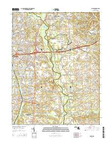
Bowie, Maryland, USGS topographic map dated 2014.
Includes geographic coordinates (latitude and longitude). This topographic map is suitable for hiking, camping, and exploring, or framing it as a wall map.
Printed on-demand using high resolution imagery, on heavy weight and acid free paper, or alternatively on a variety of synthetic materials.
Topos available on paper, Waterproof, Poly, or Tyvek. Usually shipping rolled, unless combined with other folded maps in one order.
- Product Number: USGS-7692452
- Free digital map download (high-resolution, GeoPDF): Bowie, Maryland (file size: 37 MB)
- Map Size: please refer to the dimensions of the GeoPDF map above
- Weight (paper map): ca. 55 grams
- Map Type: POD USGS Topographic Map
- Map Series: US Topo
- Map Verison: Historical
- Cell ID: 5063
- Datum: North American Datum of 1983
- Map Projection: Transverse Mercator
- Map Cell Name: Bowie
- Grid size: 7.5 X 7.5 Minute
- Date on map: 2014
- Map Scale: 1:24000
- Geographical region: Maryland, United States
Neighboring Maps:
All neighboring USGS topo maps are available for sale online at a variety of scales.
Spatial coverage:
Topo map Bowie, Maryland, covers the geographical area associated the following places:
- King Manor - Mitchellville - Cheston - Meadowoods of Davidsonville - Friends Choice - Stonegate Village - Rutland Estates - Tara - Chinquapin Crest - Patuxent River Estates - Crofton Woods - Foxhall Estates - Hall - Sherwood Manor - Davidsonville Woods - Kidwells Corner - The Greens of Crofton - Idlewild - Pigeon House Corner - Hallmark Woods - Davidsonville Farmettes - Davidsonville - Merrywood Manor - Cheval Trails - Rutland - Lake of the Pines - Velmeade - Kings Retreat - Queen Anne Knolls - Gravely - Merrywood - Royale Glen - Trails End Trailer Park - Davidsonville Gardens - Crofton South - Bladen - Overbrook - Arrowhead Farms Estates - Hanson Hills - Pin Oak Village - Bowie - Patuxent Manor - Queen Anne Estates - Hermitage Hill - Heather Hills - Riverwood - Huntington Woods - Lavall Woods - Essington - Lavall - Queen Anne - Heather Woods
- Map Area ID: AREA3938.875-76.75-76.625
- Northwest corner Lat/Long code: USGSNW39-76.75
- Northeast corner Lat/Long code: USGSNE39-76.625
- Southwest corner Lat/Long code: USGSSW38.875-76.75
- Southeast corner Lat/Long code: USGSSE38.875-76.625
- Northern map edge Latitude: 39
- Southern map edge Latitude: 38.875
- Western map edge Longitude: -76.75
- Eastern map edge Longitude: -76.625


