
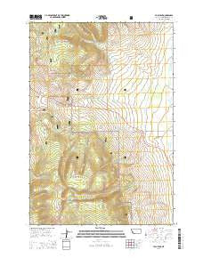
~ Tash Peak MT topo map, 1:24000 scale, 7.5 X 7.5 Minute, Current, 2014
Tash Peak, Montana, USGS topographic map dated 2014.
Includes geographic coordinates (latitude and longitude). This topographic map is suitable for hiking, camping, and exploring, or framing it as a wall map.
Printed on-demand using high resolution imagery, on heavy weight and acid free paper, or alternatively on a variety of synthetic materials.
Topos available on paper, Waterproof, Poly, or Tyvek. Usually shipping rolled, unless combined with other folded maps in one order.
- Product Number: USGS-7597915
- Free digital map download (high-resolution, GeoPDF): Tash Peak, Montana (file size: 33 MB)
- Map Size: please refer to the dimensions of the GeoPDF map above
- Weight (paper map): ca. 55 grams
- Map Type: POD USGS Topographic Map
- Map Series: US Topo
- Map Verison: Current
- Cell ID: 44333
- Datum: North American Datum of 1983
- Map Projection: Transverse Mercator
- Map Cell Name: Tash Peak
- Grid size: 7.5 X 7.5 Minute
- Date on map: 2014
- Map Scale: 1:24000
- Geographical region: Montana, United States
Neighboring Maps:
All neighboring USGS topo maps are available for sale online at a variety of scales.
Spatial coverage:
Topo map Tash Peak, Montana, covers the geographical area associated the following places:
- Cottonwood Creek - Harrison Creek - Middle Creek - East Fork Pole Creek - Abrams Creek - West Fork Pole Creek - Glidewell Creek - Scudder Creek - Harrison Creek - Big Hole Pass - Tash Peak - Neagle Creek - Picket Creek - Carroll Hill - Circle-S Ranch - Harrison Lake - Divide Creek - Farlin Creek - Harrison Peak - Harrison Canyon - Krueger Creek - Wakefield Creek - Pole Creek - 06S13W15CCCD01 Spring - 06S13W03DCAA01 Well - Rock Creek - Jager Creek - Twin Creek - Ames Creek
- Map Area ID: AREA45.37545.25-113.25-113.125
- Northwest corner Lat/Long code: USGSNW45.375-113.25
- Northeast corner Lat/Long code: USGSNE45.375-113.125
- Southwest corner Lat/Long code: USGSSW45.25-113.25
- Southeast corner Lat/Long code: USGSSE45.25-113.125
- Northern map edge Latitude: 45.375
- Southern map edge Latitude: 45.25
- Western map edge Longitude: -113.25
- Eastern map edge Longitude: -113.125


