
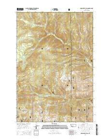
~ Crow Creek Falls MT topo map, 1:24000 scale, 7.5 X 7.5 Minute, Current, 2014
Crow Creek Falls, Montana, USGS topographic map dated 2014.
Includes geographic coordinates (latitude and longitude). This topographic map is suitable for hiking, camping, and exploring, or framing it as a wall map.
Printed on-demand using high resolution imagery, on heavy weight and acid free paper, or alternatively on a variety of synthetic materials.
Topos available on paper, Waterproof, Poly, or Tyvek. Usually shipping rolled, unless combined with other folded maps in one order.
- Product Number: USGS-7543363
- Free digital map download (high-resolution, GeoPDF): Crow Creek Falls, Montana (file size: 35 MB)
- Map Size: please refer to the dimensions of the GeoPDF map above
- Weight (paper map): ca. 55 grams
- Map Type: POD USGS Topographic Map
- Map Series: US Topo
- Map Verison: Current
- Cell ID: 10856
- Datum: North American Datum of 1983
- Map Projection: Transverse Mercator
- Map Cell Name: Crow Creek Falls
- Grid size: 7.5 X 7.5 Minute
- Date on map: 2014
- Map Scale: 1:24000
- Geographical region: Montana, United States
Neighboring Maps:
All neighboring USGS topo maps are available for sale online at a variety of scales.
Spatial coverage:
Topo map Crow Creek Falls, Montana, covers the geographical area associated the following places:
- Swamp Creek Spring - Big Tizer Wildcat Mine - Longfellow Creek - Clear Creek - Two Sam Spring - Slim Sam Basin - Big Tizer Creek - Hall Creek - Falls Creek - Crazy Creek - Dewey Creek - South Fork Lakes - Wilson Creek - Moose Creek - Manley Park - Gold Dust (historical) - Boulaway Mine - Ballard Mine - Ballard Mine - Bonanza Ridge - Blacker Creek - Calahan Mine - Pataloma Mine - Eagle Creek - Church Spring - Poe Park - Swamp Creek - Crow Creek Falls - Little Tizer Wildcat Mine - Bear Gulch - Hog Hollow Spring - Hog Hollow - Teakettle Creek - Calahan/Pataloma Mine - Little Tizer Creek - Eureka Creek - Bomar Spring - Golden Age Mine - Longfellow Park - Warner Creek - NE NE Section 3 Mine - Gold Dust Post Office (historical) - Tizer Ranger Station - Bonanza Mine - Spring Creek - Hog Hollow Mine - Bonanza Spring - Bonanza Mine
- Map Area ID: AREA46.37546.25-111.875-111.75
- Northwest corner Lat/Long code: USGSNW46.375-111.875
- Northeast corner Lat/Long code: USGSNE46.375-111.75
- Southwest corner Lat/Long code: USGSSW46.25-111.875
- Southeast corner Lat/Long code: USGSSE46.25-111.75
- Northern map edge Latitude: 46.375
- Southern map edge Latitude: 46.25
- Western map edge Longitude: -111.875
- Eastern map edge Longitude: -111.75


