
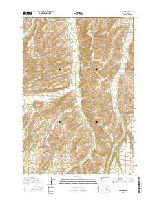
~ Castagne MT topo map, 1:24000 scale, 7.5 X 7.5 Minute, Current, 2014
Castagne, Montana, USGS topographic map dated 2014.
Includes geographic coordinates (latitude and longitude). This topographic map is suitable for hiking, camping, and exploring, or framing it as a wall map.
Printed on-demand using high resolution imagery, on heavy weight and acid free paper, or alternatively on a variety of synthetic materials.
Topos available on paper, Waterproof, Poly, or Tyvek. Usually shipping rolled, unless combined with other folded maps in one order.
- Product Number: USGS-7540052
- Free digital map download (high-resolution, GeoPDF): Castagne, Montana (file size: 29 MB)
- Map Size: please refer to the dimensions of the GeoPDF map above
- Weight (paper map): ca. 55 grams
- Map Type: POD USGS Topographic Map
- Map Series: US Topo
- Map Verison: Current
- Cell ID: 7557
- Datum: North American Datum of 1983
- Map Projection: Transverse Mercator
- Map Cell Name: Castagne
- Grid size: 7.5 X 7.5 Minute
- Date on map: 2014
- Map Scale: 1:24000
- Geographical region: Montana, United States
Neighboring Maps:
All neighboring USGS topo maps are available for sale online at a variety of scales.
Spatial coverage:
Topo map Castagne, Montana, covers the geographical area associated the following places:
- Spring Creek - Inderland-Ramsland Ditch - Caldwell Ditch - Cole Creek - 05S20E33ACBC01 Well - Thiellis Dam - Andrews Ditch - Pleasant Valley Ditch - South Willow Creek (historical) - Barlow Creek - Powers Creek - Hogan Creek - Hogan School (historical) - Harney Creek - Castagne Cemetery - Thiel Homestead Cemetery - Bull Creek - Barnett Ditch - Jackson Elementary School - John Henry Cemetery - Missouri Cutoff - Sunrise Cemetery - West Red Lodge Creek - Underwood Creek - 06S20E07BCCB01 Well - Canal S - Taylor Ditch - Thiel Creek - Antilla Ditch - Schroeder Gulch - Castagne - Castagne Post Office (historical) - Crane Ditch - Roberts Division - Doty Ditch - East Red Lodge Creek
- Map Area ID: AREA45.37545.25-109.375-109.25
- Northwest corner Lat/Long code: USGSNW45.375-109.375
- Northeast corner Lat/Long code: USGSNE45.375-109.25
- Southwest corner Lat/Long code: USGSSW45.25-109.375
- Southeast corner Lat/Long code: USGSSE45.25-109.25
- Northern map edge Latitude: 45.375
- Southern map edge Latitude: 45.25
- Western map edge Longitude: -109.375
- Eastern map edge Longitude: -109.25


