
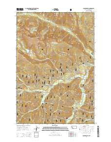
~ Boulder Peak MT topo map, 1:24000 scale, 7.5 X 7.5 Minute, Current, 2014
Boulder Peak, Montana, USGS topographic map dated 2014.
Includes geographic coordinates (latitude and longitude). This topographic map is suitable for hiking, camping, and exploring, or framing it as a wall map.
Printed on-demand using high resolution imagery, on heavy weight and acid free paper, or alternatively on a variety of synthetic materials.
Topos available on paper, Waterproof, Poly, or Tyvek. Usually shipping rolled, unless combined with other folded maps in one order.
- Product Number: USGS-7539614
- Free digital map download (high-resolution, GeoPDF): Boulder Peak, Montana (file size: 40 MB)
- Map Size: please refer to the dimensions of the GeoPDF map above
- Weight (paper map): ca. 55 grams
- Map Type: POD USGS Topographic Map
- Map Series: US Topo
- Map Verison: Current
- Cell ID: 4984
- Datum: North American Datum of 1983
- Map Projection: Transverse Mercator
- Map Cell Name: Boulder Peak
- Grid size: 7.5 X 7.5 Minute
- Date on map: 2014
- Map Scale: 1:24000
- Geographical region: Montana, United States
Neighboring Maps:
All neighboring USGS topo maps are available for sale online at a variety of scales.
Spatial coverage:
Topo map Boulder Peak, Montana, covers the geographical area associated the following places:
- Sentimental Creek - Trapper Peak Trail - Buck Creek - Little West Fork Campground - Wheeler Creek - Basin Creek - Nez Perce Fork - Slide Creek - West Fork Ranger Station - Swamp Creek - Krueger Ranch - Soda Springs - Rombo Creek - Ditch Creek - Ward Creek - Lake of the Rocks - One Creek - Rombo Cemetery - Beetle Gulch - Boulder Falls - Gemmell Creek - Soda Springs Creek - School Point - Bonnie Blue Creek - Beavertail Creek - West Fork Volunteer Fire Department Station 2 - Boulder Peak - Nelson Lake - Two Creek - Little West Fork - Barn Draw - Nelson Creek - Halford Creek - Old Nez Perce Indian Trail - Boulder Point - Rombo Creek Campground - Crow Creek - Surprise Creek - Brickley Stage Stop (historical) - Mink Creek
- Map Area ID: AREA45.87545.75-114.375-114.25
- Northwest corner Lat/Long code: USGSNW45.875-114.375
- Northeast corner Lat/Long code: USGSNE45.875-114.25
- Southwest corner Lat/Long code: USGSSW45.75-114.375
- Southeast corner Lat/Long code: USGSSE45.75-114.25
- Northern map edge Latitude: 45.875
- Southern map edge Latitude: 45.75
- Western map edge Longitude: -114.375
- Eastern map edge Longitude: -114.25


