
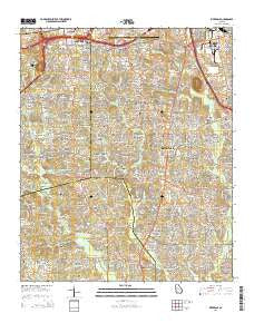
~ Riverdale GA topo map, 1:24000 scale, 7.5 X 7.5 Minute, Current, 2014
Riverdale, Georgia, USGS topographic map dated 2014.
Includes geographic coordinates (latitude and longitude). This topographic map is suitable for hiking, camping, and exploring, or framing it as a wall map.
Printed on-demand using high resolution imagery, on heavy weight and acid free paper, or alternatively on a variety of synthetic materials.
Topos available on paper, Waterproof, Poly, or Tyvek. Usually shipping rolled, unless combined with other folded maps in one order.
- Product Number: USGS-7536755
- Free digital map download (high-resolution, GeoPDF): Riverdale, Georgia (file size: 37 MB)
- Map Size: please refer to the dimensions of the GeoPDF map above
- Weight (paper map): ca. 55 grams
- Map Type: POD USGS Topographic Map
- Map Series: US Topo
- Map Verison: Current
- Cell ID: 38041
- Datum: North American Datum of 1983
- Map Projection: Transverse Mercator
- Map Cell Name: Riverdale
- Grid size: 7.5 X 7.5 Minute
- Date on map: 2014
- Map Scale: 1:24000
- Geographical region: Georgia, United States
Neighboring Maps:
All neighboring USGS topo maps are available for sale online at a variety of scales.
Spatial coverage:
Topo map Riverdale, Georgia, covers the geographical area associated the following places:
- Saranac Estates - Saranac - Marlborough - Castile Cove - Morning Creek Estates - Dix-Leeson - Gamma - West Road Acres - Rebecca Lake Estates - Ansley Pointe - Beaver Creek - Wesley Park - Gatewood - Dartmouth Estates - Kings Forest - Graves Way - Highland Hills - Green Acres - Camp Creek Estates - Biscayne Club - Bethesda Woods South - Cheeko Manor - Stanebrook - Roundtree Estates - Skylane Hills - Red Gate Estates - Thornton Woods - Kimberly - Brandy Chase - Windermere Woods - Smoke Ridge - Pointe South Place - Hopeful - Glenwoods - Princeton Chase - Chippewa Forest - Limetree - Laurel Woods - Bethsaida Woods - Clayton Ridge - Valley Woods - Bethsaida West - Briarwood - Dover Meadows - Deerwood Park - Carnegie Place - Franklin Farms - Spring Valley - Valley Forest - Mockingbird Hill - Helmer - Hollydale - Beaver Lake Estates - Red Oak - Sussex Manor - Kenwood - Twin Creeks - Crystal Acres - Friendship - Fox Run - Briargate - Old Ford Acres - Timberland Heights - Hidden Acres of Fayette - Cedar Hill Estates - Woodland Hills Mobile Home Park - Quail Valley - Frog Hollow - Ponderosa - Lakeview Heights - Castlegate - Jackson Estates - Windy Hill Manor - Park Villas - Aspen Acres - Oak Village - Williamsburg Park - Lafayette Estates - Evans Park - Chase Woods - Riverdale Acres - Taylor Crossing - Heatherwood - Willow Creek Estates - Lexington Creek - Hallie Hills - Levgard Estates - Hillandale - Newton Plantation - Brooks Manor - Kenwood Forest - Northridge - The Willows - Normandy - Pleasant Hill - Wewoka Estates - Ashley Park - Embassy Estates - Otranto Hills - River Valley Estates
- Map Area ID: AREA33.62533.5-84.5-84.375
- Northwest corner Lat/Long code: USGSNW33.625-84.5
- Northeast corner Lat/Long code: USGSNE33.625-84.375
- Southwest corner Lat/Long code: USGSSW33.5-84.5
- Southeast corner Lat/Long code: USGSSE33.5-84.375
- Northern map edge Latitude: 33.625
- Southern map edge Latitude: 33.5
- Western map edge Longitude: -84.5
- Eastern map edge Longitude: -84.375


