
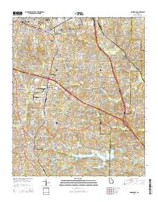
~ Jonesboro GA topo map, 1:24000 scale, 7.5 X 7.5 Minute, Current, 2014
Jonesboro, Georgia, USGS topographic map dated 2014.
Includes geographic coordinates (latitude and longitude). This topographic map is suitable for hiking, camping, and exploring, or framing it as a wall map.
Printed on-demand using high resolution imagery, on heavy weight and acid free paper, or alternatively on a variety of synthetic materials.
Topos available on paper, Waterproof, Poly, or Tyvek. Usually shipping rolled, unless combined with other folded maps in one order.
- Product Number: USGS-7536221
- Free digital map download (high-resolution, GeoPDF): Jonesboro, Georgia (file size: 36 MB)
- Map Size: please refer to the dimensions of the GeoPDF map above
- Weight (paper map): ca. 55 grams
- Map Type: POD USGS Topographic Map
- Map Series: US Topo
- Map Verison: Current
- Cell ID: 72687
- Datum: North American Datum of 1983
- Map Projection: Transverse Mercator
- Map Cell Name: Jonesboro
- Grid size: 7.5 X 7.5 Minute
- Date on map: 2014
- Map Scale: 1:24000
- Geographical region: Georgia, United States
Neighboring Maps:
All neighboring USGS topo maps are available for sale online at a variety of scales.
Spatial coverage:
Topo map Jonesboro, Georgia, covers the geographical area associated the following places:
- Weybridge - Clearbrook - Ace Mobile Home Park - Blueridge Mountain Mobile Home Park - Holiday Hills - Fielder Manor - Red Oak - Creek Hollow - Bretton Woods - Green Meadows - Bobilin Estates - Burkshire - Rex - Charlotte Woods - Sunset Hills - Beverly Hills - Morrow - Old South - Wilkshire Estates - Fernwood - Glenn Devon - Canterbury Woods - Hickory Hills - Maple Grove - Orchard Hills - Jonesboro - Creekwood Estates - Haven Park - Devonshire - Springview - Oak Forest - Drakes Landing - Embrey Hills - Wildwood Estates - Ellenwood Homes - Homestead - Pinebrook Heights - Heather Lynn - Windhaven Plantation - Jarrard - Ambleside - Thornton Estates - Barcelona Estates - Stagecoach Manor - Knollwood - Sun Valley - Lake Spivey Estates - Lake Tara - Fairlane - Katherine Valley - Pooles Mobile Home Park - Rum Bridge Estates - Meadowview Acres - Vinton Woods - Tiffany Hills - Ellenwood - Mayday (historical) - Springfield - Dogwood Acres - Clayton Manor - Emerald Hills - Foxfield - Woodlawn Acres - Harbin Acres - Pinecrest Forest - University Estates - Rolling Meadows - North Clayton - Allendale Heights - Oak Ridge - Spivey Chase - Woodfield - Lake Jodeco - Park Forest - Forest Park - Lake City - Kunuga Hills - Edgemoor Manor - Paradise Park - Chestnut Lake Estates - Woodstone - Indian Hill Estates - Hidden Hollow - Carol Woods - The Inlet - Amber Wood Estates - Sherwood Forest
- Map Area ID: AREA33.62533.5-84.375-84.25
- Northwest corner Lat/Long code: USGSNW33.625-84.375
- Northeast corner Lat/Long code: USGSNE33.625-84.25
- Southwest corner Lat/Long code: USGSSW33.5-84.375
- Southeast corner Lat/Long code: USGSSE33.5-84.25
- Northern map edge Latitude: 33.625
- Southern map edge Latitude: 33.5
- Western map edge Longitude: -84.375
- Eastern map edge Longitude: -84.25


