
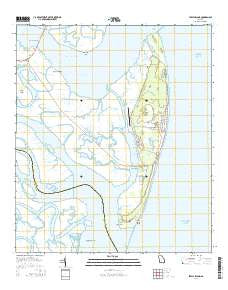
~ Jekyll Island GA topo map, 1:24000 scale, 7.5 X 7.5 Minute, Current, 2014
Jekyll Island, Georgia, USGS topographic map dated 2014.
Includes geographic coordinates (latitude and longitude). This topographic map is suitable for hiking, camping, and exploring, or framing it as a wall map.
Printed on-demand using high resolution imagery, on heavy weight and acid free paper, or alternatively on a variety of synthetic materials.
Topos available on paper, Waterproof, Poly, or Tyvek. Usually shipping rolled, unless combined with other folded maps in one order.
- Product Number: USGS-7536219
- Free digital map download (high-resolution, GeoPDF): Jekyll Island, Georgia (file size: 25 MB)
- Map Size: please refer to the dimensions of the GeoPDF map above
- Weight (paper map): ca. 55 grams
- Map Type: POD USGS Topographic Map
- Map Series: US Topo
- Map Verison: Current
- Cell ID: 70495
- Datum: North American Datum of 1983
- Map Projection: Transverse Mercator
- Map Cell Name: Jekyll Island
- Grid size: 7.5 X 7.5 Minute
- Date on map: 2014
- Map Scale: 1:24000
- Geographical region: Georgia, United States
Neighboring Maps:
All neighboring USGS topo maps are available for sale online at a variety of scales.
Spatial coverage:
Topo map Jekyll Island, Georgia, covers the geographical area associated the following places:
- Jekyll Island Golf Club - East River - Jekyll Convention Center - Brunswick River - Umbrella Creek - Clam Creek Picnic Area - Beachside Shopping Center - Jekyll Island - Jekyll Creek - Little Satilla River - Jekyll Island Airport - Cedar Hammock - Cobb Creek - Salt Pot Creek - Cedar Creek - Brunswick Point - Jointer Creek - Beach Creek - Saint Andrews Picnic Area - DuBignon Cemetery - Jekyll Island State Park Authority - Clam Creek - Jekyll Island Water Pollution Control Plant - Dever Cut - Raccoon Key Spit - Parsons Creek - Saint Andrew Beach - Faith Chapel - Du Bianons Creek - Jekyll Island Plaza Shopping Center - Latham River - Indian Mound Golf Club - Turtle River - Jekyll Wharf Marina - Jekyll Island Fire Department - Jekyll Island Museum - Sidney Lanier Bridge - Ruins of Georgias First Brewery - M E Thompson Memorial Bridge - Georgia State Patrol Troop I Post 35 Jekyll Island - Jekyll Point - Jekyll Island Post Office - Jekyll Harbor - Jekyll Sound - Jekyll Island Division - Umbrella Cut - Cherokee Campground - Mud River
- Map Area ID: AREA31.12531-81.5-81.375
- Northwest corner Lat/Long code: USGSNW31.125-81.5
- Northeast corner Lat/Long code: USGSNE31.125-81.375
- Southwest corner Lat/Long code: USGSSW31-81.5
- Southeast corner Lat/Long code: USGSSE31-81.375
- Northern map edge Latitude: 31.125
- Southern map edge Latitude: 31
- Western map edge Longitude: -81.5
- Eastern map edge Longitude: -81.375


