
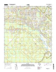
~ Stallsville SC topo map, 1:24000 scale, 7.5 X 7.5 Minute, Current, 2014
Stallsville, South Carolina, USGS topographic map dated 2014.
Includes geographic coordinates (latitude and longitude). This topographic map is suitable for hiking, camping, and exploring, or framing it as a wall map.
Printed on-demand using high resolution imagery, on heavy weight and acid free paper, or alternatively on a variety of synthetic materials.
Topos available on paper, Waterproof, Poly, or Tyvek. Usually shipping rolled, unless combined with other folded maps in one order.
- Product Number: USGS-7477716
- Free digital map download (high-resolution, GeoPDF): Stallsville, South Carolina (file size: 36 MB)
- Map Size: please refer to the dimensions of the GeoPDF map above
- Weight (paper map): ca. 55 grams
- Map Type: POD USGS Topographic Map
- Map Series: US Topo
- Map Verison: Current
- Cell ID: 42834
- Datum: North American Datum of 1983
- Map Projection: Transverse Mercator
- Map Cell Name: Stallsville
- Grid size: 7.5 X 7.5 Minute
- Date on map: 2014
- Map Scale: 1:24000
- Geographical region: South Carolina, United States
Neighboring Maps:
All neighboring USGS topo maps are available for sale online at a variety of scales.
Spatial coverage:
Topo map Stallsville, South Carolina, covers the geographical area associated the following places:
- Coventry Place - Fairlawn Terrace - Woodlawn - Oakmont - Westoe - Stallsville - Tranquil Estates - Dorchester (historical) - Jamison Terrace - Evergreen - Kings Grant - Iron Gate - Dorchester Estates - Ashley Forest - Woodland Estates - Old Fort Estates - Ashley Retreat - Summerwood - Dorchester Crossing - Marlin Estates - White Church Place - Cooke Crossroads - Laurel Hill - Plantation Ridge - Crichton Parish - Ashborough East - Chandler Village - Briarwood - Crestwood - Wood Oak Park - Creekside - Centerville - Barney Ridge - Ashborough - Moss Point - Greenhurst - Indian Springs - Southern Palms - Tranquil Acres - Chandler Lakes - Summerville Place - Summerville Farms - Avenue of Oaks - Salisbury Acres - West Oaks - Calomet Valley - Greggs Landing - Farmdale - Flowertown Village - Waters Edge - Country Club Estates - Sprucewood - Slandsville - Newington Plantation - Oakbrook - Quail Arbor - Oakdale Estates
- Map Area ID: AREA3332.875-80.25-80.125
- Northwest corner Lat/Long code: USGSNW33-80.25
- Northeast corner Lat/Long code: USGSNE33-80.125
- Southwest corner Lat/Long code: USGSSW32.875-80.25
- Southeast corner Lat/Long code: USGSSE32.875-80.125
- Northern map edge Latitude: 33
- Southern map edge Latitude: 32.875
- Western map edge Longitude: -80.25
- Eastern map edge Longitude: -80.125


