
~ Wilson Mountain AZ topo map, 1:24000 scale, 7.5 X 7.5 Minute, 2014
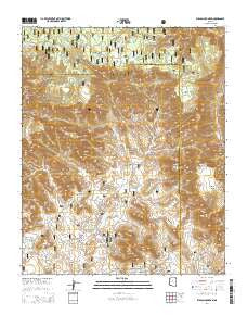
Wilson Mountain, Arizona, USGS topographic map dated 2014.
Includes geographic coordinates (latitude and longitude). This topographic map is suitable for hiking, camping, and exploring, or framing it as a wall map.
Printed on-demand using high resolution imagery, on heavy weight and acid free paper, or alternatively on a variety of synthetic materials.
Topos available on paper, Waterproof, Poly, or Tyvek. Usually shipping rolled, unless combined with other folded maps in one order.
- Product Number: USGS-7263860
- Free digital map download (high-resolution, GeoPDF): Wilson Mountain, Arizona (file size: 31 MB)
- Map Size: please refer to the dimensions of the GeoPDF map above
- Weight (paper map): ca. 55 grams
- Map Type: POD USGS Topographic Map
- Map Series: US Topo
- Map Verison: Current
- Cell ID: 49339
- Datum: North American Datum of 1983
- Map Projection: Transverse Mercator
- Map Cell Name: Wilson Mountain
- Grid size: 7.5 X 7.5 Minute
- Date on map: 2014
- Map Scale: 1:24000
- Geographical region: Arizona, United States
Neighboring Maps:
All neighboring USGS topo maps are available for sale online at a variety of scales.
Spatial coverage:
Topo map Wilson Mountain, Arizona, covers the geographical area associated the following places:
- Mos Tank - Barney Pasture Burn - Secret Canyon - Lost Wilson Mountain - Sterling Canyon - Chimney Rock - Hancock Cabin Tank - Long Canyon - Maroon Mountain - Little Round Mountain - Boynton Canyon - Halfway Picnic Area - View Point - Boynton Pass - South Pocket Tank - Vultee Arch - Barney Spring - Bootlegger Campground - South Pocket - Lil Round Tank - Devils Kitchen - Doe Mountain - Coffeepot Rock - Banjo Bill Campground - Rattlesnake Tank - H S Canyon - Pine Tank - Capitol Butte - Marshall Tank - Rattlesnake Mesa - Loy Tank - Soldier Pass - Devils Bridge - Brins Mesa - Indian Head Arch - Round Top Mountain - OK Tank - East Pocket Lookout Tower - Red Rock-Secret Mountain Wilderness - Buckhead Ridge - Steamboat Rock - East Pocket - Burn Tank - Bear Sign Canyon - Barney Pasture - Side Rock Campground - Vultee Arch Twenty Two - The Cockscomb - Fay Canyon Arch - Earls Tank - Mescal Mountain - Wilson Mountain - Buckshead Tank - Buckhead Point - Sedona-Oak Creek Golf Course - AM Tank - Slide Rock Swim Area - Test Hole Tank - Bridle Trail - First Tank - Grassy Knolls - Fay Canyon - Wilson Tank - Crater Tank - East Pocket Tank - East Pocket Knob
- Map Area ID: AREA3534.875-111.875-111.75
- Northwest corner Lat/Long code: USGSNW35-111.875
- Northeast corner Lat/Long code: USGSNE35-111.75
- Southwest corner Lat/Long code: USGSSW34.875-111.875
- Southeast corner Lat/Long code: USGSSE34.875-111.75
- Northern map edge Latitude: 35
- Southern map edge Latitude: 34.875
- Western map edge Longitude: -111.875
- Eastern map edge Longitude: -111.75


