
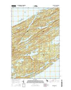
~ Lake Richie MI topo map, 1:24000 scale, 7.5 X 7.5 Minute, Historical, 2014
Lake Richie, Michigan, USGS topographic map dated 2014.
Includes geographic coordinates (latitude and longitude). This topographic map is suitable for hiking, camping, and exploring, or framing it as a wall map.
Printed on-demand using high resolution imagery, on heavy weight and acid free paper, or alternatively on a variety of synthetic materials.
Topos available on paper, Waterproof, Poly, or Tyvek. Usually shipping rolled, unless combined with other folded maps in one order.
- Product Number: USGS-7262492
- Free digital map download (high-resolution, GeoPDF): Lake Richie, Michigan (file size: 37 MB)
- Map Size: please refer to the dimensions of the GeoPDF map above
- Weight (paper map): ca. 55 grams
- Map Type: POD USGS Topographic Map
- Map Series: US Topo
- Map Verison: Historical
- Cell ID: 74875
- Datum: North American Datum of 1983
- Map Projection: Transverse Mercator
- Map Cell Name: Lake Richie
- Grid size: 7.5 X 7.5 Minute
- Date on map: 2014
- Map Scale: 1:24000
- Geographical region: Michigan, United States
Neighboring Maps:
All neighboring USGS topo maps are available for sale online at a variety of scales.
Spatial coverage:
Topo map Lake Richie, Michigan, covers the geographical area associated the following places:
- Hawk Island - Lake Richie Campground - Brady Cove - Pine Mountain - Blueberry Cove - Chickenbone Lake - Sargent Lake - Moskey Basin - Lake Whittlesey - Lake George - McCargoe Cove - The Narrows - McCargoe Cove Campground - Lake Mason - Chippewa Harbor - East Chickenbone Lake Campground - Linklater Lake - Birch Island Campground - Lake Richie - McDonald Lake - Lake Wagejo - Ollies Dogs Rocks - Greenstone Beach - Intermediate Lake - Hastings Island - Indian Portage Trail - Birch Island - Lake Dustin - Angleworm Lake - Moskey Basin Campground - Lake Livermore - Lake Richie Trail - Lake Scholts - Chippewa Harbor Campground - Wallace Lake - Lake Theresa - Wood Lake - Lake Eva - Minong Post Office (historical) - West Chickenbone Lake Campground - Birch Isle - Lake Shesheeb - Lake Benson - LeSage Lake - Indian Point - Stanley Ridge - Minong Mine
- Map Area ID: AREA48.12548-88.75-88.625
- Northwest corner Lat/Long code: USGSNW48.125-88.75
- Northeast corner Lat/Long code: USGSNE48.125-88.625
- Southwest corner Lat/Long code: USGSSW48-88.75
- Southeast corner Lat/Long code: USGSSE48-88.625
- Northern map edge Latitude: 48.125
- Southern map edge Latitude: 48
- Western map edge Longitude: -88.75
- Eastern map edge Longitude: -88.625


