
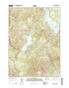
~ Hyatt Reservoir OR topo map, 1:24000 scale, 7.5 X 7.5 Minute, Current, 2014
Hyatt Reservoir, Oregon, USGS topographic map dated 2014.
Includes geographic coordinates (latitude and longitude). This topographic map is suitable for hiking, camping, and exploring, or framing it as a wall map.
Printed on-demand using high resolution imagery, on heavy weight and acid free paper, or alternatively on a variety of synthetic materials.
Topos available on paper, Waterproof, Poly, or Tyvek. Usually shipping rolled, unless combined with other folded maps in one order.
- Product Number: USGS-7260230
- Free digital map download (high-resolution, GeoPDF): Hyatt Reservoir, Oregon (file size: 40 MB)
- Map Size: please refer to the dimensions of the GeoPDF map above
- Weight (paper map): ca. 55 grams
- Map Type: POD USGS Topographic Map
- Map Series: US Topo
- Map Verison: Current
- Cell ID: 21626
- Datum: North American Datum of 1983
- Map Projection: Transverse Mercator
- Map Cell Name: Hyatt Reservoir
- Grid size: 7.5 X 7.5 Minute
- Date on map: 2014
- Map Scale: 1:24000
- Geographical region: Oregon, United States
Neighboring Maps:
All neighboring USGS topo maps are available for sale online at a variety of scales.
Spatial coverage:
Topo map Hyatt Reservoir, Oregon, covers the geographical area associated the following places:
- East Fork Corral Creek - Little Rock Spring - Green Springs Summit - Willow Creek - Fawn Island - Grizzly Prairie (historical) - Hyatt Lake Resort Campers Cove Dock - Hyatt Lake Resort Marina - Howard Prairie County Resort - South Fork Beaver Creek - Hyatt Lake Resort Boat Ramp - Howard Prairie County Recreation Area - Southeast Jackson Division - Klum Landing County Campground - Howard Prairie Dam - Burnt Creek Ranch - Cottonwood Creek - Hyatt Reservoir - Fairchild Spring - Klum Landing Jackson County Boat Ramp - Crane Prairie - Asperkaha County Campground - Little Hyatt Reservoir - Keene Creek Reservoir - Howard Prairie Lake Resort Marina - Hoxie Creek - Keene Creek Dam - Buck Prairie - Howard Prairie (historical) - Hyatt Lake Campground - Buck Island - Hyatt Lake Bureau of Land Management Boat Ramp - Summit Ranch - Keene Creek Diversion Dam - Hyatt Meadows - Burnt Creek - Table Mountain - Hyatt Lake Bureau of Land Management Boat Ramp - Chinquapin Mountain - Cottonwood Glades - Howard Prairie Resort Jackson County Boat Ramp - Sugar Pine County Group Campground - Swinning Spring - Swinning Creek - Howard Prairie Lake - Wildcat Glades - Hyatt Lake Bureau of Land Management Boat Ramp - Willow Point Jackson County Boat Ramp - Doe Island - Willow Point County Campground
- Map Area ID: AREA42.2542.125-122.5-122.375
- Northwest corner Lat/Long code: USGSNW42.25-122.5
- Northeast corner Lat/Long code: USGSNE42.25-122.375
- Southwest corner Lat/Long code: USGSSW42.125-122.5
- Southeast corner Lat/Long code: USGSSE42.125-122.375
- Northern map edge Latitude: 42.25
- Southern map edge Latitude: 42.125
- Western map edge Longitude: -122.5
- Eastern map edge Longitude: -122.375


