
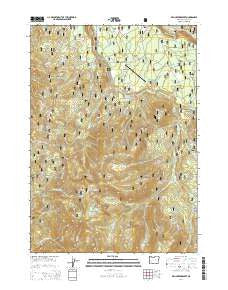
~ Fish Creek Desert OR topo map, 1:24000 scale, 7.5 X 7.5 Minute, Current, 2014
Fish Creek Desert, Oregon, USGS topographic map dated 2014.
Includes geographic coordinates (latitude and longitude). This topographic map is suitable for hiking, camping, and exploring, or framing it as a wall map.
Printed on-demand using high resolution imagery, on heavy weight and acid free paper, or alternatively on a variety of synthetic materials.
Topos available on paper, Waterproof, Poly, or Tyvek. Usually shipping rolled, unless combined with other folded maps in one order.
- Product Number: USGS-7259616
- Free digital map download (high-resolution, GeoPDF): Fish Creek Desert, Oregon (file size: 40 MB)
- Map Size: please refer to the dimensions of the GeoPDF map above
- Weight (paper map): ca. 55 grams
- Map Type: POD USGS Topographic Map
- Map Series: US Topo
- Map Verison: Current
- Cell ID: 15329
- Datum: North American Datum of 1983
- Map Projection: Transverse Mercator
- Map Cell Name: Fish Creek Desert
- Grid size: 7.5 X 7.5 Minute
- Date on map: 2014
- Map Scale: 1:24000
- Geographical region: Oregon, United States
Neighboring Maps:
All neighboring USGS topo maps are available for sale online at a variety of scales.
Spatial coverage:
Topo map Fish Creek Desert, Oregon, covers the geographical area associated the following places:
- Happy Valley - Grave Creek - Slipper Creek - Mud Lake Mountain - Watson Falls - Fawn Lake - Toketee State Airport - Clear Creek - Camas Creek - Rough Creek - Brodie Creek - Fawn Creek - Black Rock - Camas Creek Campground - Black Rock Trail - Rolling Grounds - Cedar Spring - Pine Creek - Rolling Grounds Camp - Rattlesnake Way - Beaver Shelter - Fish Creek Reservoir - Rhododendron Ridge - Whitehorse Meadows - Wolf Lake - Grave Creek Trail - The Jumpoff - Watson Falls Recreation Site - Fish Creek Campground - Fish Creek Canal - Greek Creek - Black Rock Creek - No Tunnel Creek - Fish Creek Desert - Quartz Canyon - Eva Creek - Fish Creek Dam - Big Camp Ranger Station (historical) - French Junction
- Map Area ID: AREA43.2543.125-122.5-122.375
- Northwest corner Lat/Long code: USGSNW43.25-122.5
- Northeast corner Lat/Long code: USGSNE43.25-122.375
- Southwest corner Lat/Long code: USGSSW43.125-122.5
- Southeast corner Lat/Long code: USGSSE43.125-122.375
- Northern map edge Latitude: 43.25
- Southern map edge Latitude: 43.125
- Western map edge Longitude: -122.5
- Eastern map edge Longitude: -122.375


