
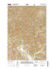
~ Euchre Mountain OR topo map, 1:24000 scale, 7.5 X 7.5 Minute, Current, 2014
Euchre Mountain, Oregon, USGS topographic map dated 2014.
Includes geographic coordinates (latitude and longitude). This topographic map is suitable for hiking, camping, and exploring, or framing it as a wall map.
Printed on-demand using high resolution imagery, on heavy weight and acid free paper, or alternatively on a variety of synthetic materials.
Topos available on paper, Waterproof, Poly, or Tyvek. Usually shipping rolled, unless combined with other folded maps in one order.
- Product Number: USGS-7259418
- Free digital map download (high-resolution, GeoPDF): Euchre Mountain, Oregon (file size: 38 MB)
- Map Size: please refer to the dimensions of the GeoPDF map above
- Weight (paper map): ca. 55 grams
- Map Type: POD USGS Topographic Map
- Map Series: US Topo
- Map Verison: Current
- Cell ID: 14612
- Datum: North American Datum of 1983
- Map Projection: Transverse Mercator
- Map Cell Name: Euchre Mountain
- Grid size: 7.5 X 7.5 Minute
- Date on map: 2014
- Map Scale: 1:24000
- Geographical region: Oregon, United States
Neighboring Maps:
All neighboring USGS topo maps are available for sale online at a variety of scales.
Spatial coverage:
Topo map Euchre Mountain, Oregon, covers the geographical area associated the following places:
- Peck Cabin - Elk Creek - Holman Creek - Sunshine Creek - Lambert Point - Coon Creek - Euchre Mountain - Savage Creek - Moonshine Park Boat Launch - Little Euchre Mountain - Palmer Creek - Wildcat Creek - East Fork Buck Creek - Gunn Creek - Moonshine County Park - Baker Creek - Powderhouse Hole - Euchre Falls - Cerine Creek - Black Tank Saddle - Sugarloaf Post Office (historical) - Upper Farm - Siletz Division - West Fork Buck Creek - South Fork Buck Creek - Wolfer Creek - Gorge Camp - Werner Camp (historical) - Buck Creek - North Fork Mill Creek - Wildcat Ridge - Gobblers Knob - Lower Gorge - South Fork Mill Creek
- Map Area ID: AREA44.87544.75-123.875-123.75
- Northwest corner Lat/Long code: USGSNW44.875-123.875
- Northeast corner Lat/Long code: USGSNE44.875-123.75
- Southwest corner Lat/Long code: USGSSW44.75-123.875
- Southeast corner Lat/Long code: USGSSE44.75-123.75
- Northern map edge Latitude: 44.875
- Southern map edge Latitude: 44.75
- Western map edge Longitude: -123.875
- Eastern map edge Longitude: -123.75


