
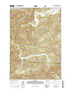
~ Digger Mountain OR topo map, 1:24000 scale, 7.5 X 7.5 Minute, Current, 2014
Digger Mountain, Oregon, USGS topographic map dated 2014.
Includes geographic coordinates (latitude and longitude). This topographic map is suitable for hiking, camping, and exploring, or framing it as a wall map.
Printed on-demand using high resolution imagery, on heavy weight and acid free paper, or alternatively on a variety of synthetic materials.
Topos available on paper, Waterproof, Poly, or Tyvek. Usually shipping rolled, unless combined with other folded maps in one order.
- Product Number: USGS-7259248
- Free digital map download (high-resolution, GeoPDF): Digger Mountain, Oregon (file size: 35 MB)
- Map Size: please refer to the dimensions of the GeoPDF map above
- Weight (paper map): ca. 55 grams
- Map Type: POD USGS Topographic Map
- Map Series: US Topo
- Map Verison: Current
- Cell ID: 12263
- Datum: North American Datum of 1983
- Map Projection: Transverse Mercator
- Map Cell Name: Digger Mountain
- Grid size: 7.5 X 7.5 Minute
- Date on map: 2014
- Map Scale: 1:24000
- Geographical region: Oregon, United States
Neighboring Maps:
All neighboring USGS topo maps are available for sale online at a variety of scales.
Spatial coverage:
Topo map Digger Mountain, Oregon, covers the geographical area associated the following places:
- Salmonberry Creek - Jasper Creek - Martha Creek - Digger Mountain - North Fork Salmonberry Creek - Box Post Office (historical) - Campbell County Park - Bovine Creek - Lobster Valley - Briar Creek - Cook Creek - Burch Creek - Schoolhouse Creek - Box (historical) - Meadow Creek - Missouri Bend Recreation Site - Benner Creek - Campbell Boat Landing - Coal Bank Creek - Missouri Bend School - Alsea Valley - Preacher Creek - Little Lobster Creek - Taylor Butte - Salmonberry Boat Landing - Maltby Creek - South Fork Salmonberry Creek - Lone Fir Cemetery - Bear Creek - Scoville Spring - Salmonberry County Park & Campground - Lobster Post Office (historical) - Narrow Creek - Yew Wood Camp (historical) - Missouri Bend - Wilkinson Creek - Little Lobster Summit
- Map Area ID: AREA44.37544.25-123.75-123.625
- Northwest corner Lat/Long code: USGSNW44.375-123.75
- Northeast corner Lat/Long code: USGSNE44.375-123.625
- Southwest corner Lat/Long code: USGSSW44.25-123.75
- Southeast corner Lat/Long code: USGSSE44.25-123.625
- Northern map edge Latitude: 44.375
- Southern map edge Latitude: 44.25
- Western map edge Longitude: -123.75
- Eastern map edge Longitude: -123.625


