
~ Bull of the Woods OR topo map, 1:24000 scale, 7.5 X 7.5 Minute, Current, 2014
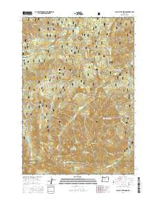
Bull of the Woods, Oregon, USGS topographic map dated 2014.
Includes geographic coordinates (latitude and longitude). This topographic map is suitable for hiking, camping, and exploring, or framing it as a wall map.
Printed on-demand using high resolution imagery, on heavy weight and acid free paper, or alternatively on a variety of synthetic materials.
Topos available on paper, Waterproof, Poly, or Tyvek. Usually shipping rolled, unless combined with other folded maps in one order.
- Product Number: USGS-7258663
- Free digital map download (high-resolution, GeoPDF): Bull of the Woods, Oregon (file size: 38 MB)
- Map Size: please refer to the dimensions of the GeoPDF map above
- Weight (paper map): ca. 55 grams
- Map Type: POD USGS Topographic Map
- Map Series: US Topo
- Map Verison: Current
- Cell ID: 6138
- Datum: North American Datum of 1983
- Map Projection: Transverse Mercator
- Map Cell Name: Bull of the Woods
- Grid size: 7.5 X 7.5 Minute
- Date on map: 2014
- Map Scale: 1:24000
- Geographical region: Oregon, United States
Neighboring Maps:
All neighboring USGS topo maps are available for sale online at a variety of scales.
Spatial coverage:
Topo map Bull of the Woods, Oregon, covers the geographical area associated the following places:
- Farm Trail - Pink Creek - Welcome Lakes Trail - Knob Rock Creek - Alder Swamp Shelter - Pansy Mountain - North Dickey Peak - Dickey Creek - West Lake - Thunder Creek - Bull of the Woods - Hot Springs Fork - Dunno Creek - Pine Cone Creek - Russ Creek - Lily Pad Quarry - Buckeye Creek - Welcome Lakes - Granite Peaks - Farm Creek - Blitzen Creek - Kingfisher Recreation Site - Happy Creek - Van Cleve Creek - Elk Lake Creek - Schreiner Peak - Russ Creek Quarry - Big Slide Lake - Cat Creek - Toms Meadow - Pansy Lake - Welcome Creek - Paste Creek - Terrace Spring - Fan Creek - Dickey Lake - Pasola Mountain - Lake Lenore - Knob Peak - Slide Creek - Ogre Creek - South Dickey Peak - Thunder Mountain Trail - Little Fan Creek Campground - Lily Pad Lake - Happy Quarry - Bull of the Woods Trail - Bagby Trail - Peat Creek - Bull of the Woods Wilderness - East Fork Collawash River - Sand Creek - Dutch Creek Shelter - Big Slide Mountain - Calog Quarry - Jazz Creek - Oh Boy Forest Camp - Dutch Creek - Pansy Basin
- Map Area ID: AREA4544.875-122.125-122
- Northwest corner Lat/Long code: USGSNW45-122.125
- Northeast corner Lat/Long code: USGSNE45-122
- Southwest corner Lat/Long code: USGSSW44.875-122.125
- Southeast corner Lat/Long code: USGSSE44.875-122
- Northern map edge Latitude: 45
- Southern map edge Latitude: 44.875
- Western map edge Longitude: -122.125
- Eastern map edge Longitude: -122


