
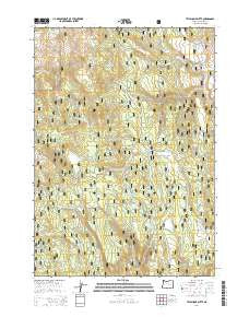
~ Telephone Butte OR topo map, 1:24000 scale, 7.5 X 7.5 Minute, Current, 2014
Telephone Butte, Oregon, USGS topographic map dated 2014.
Includes geographic coordinates (latitude and longitude). This topographic map is suitable for hiking, camping, and exploring, or framing it as a wall map.
Printed on-demand using high resolution imagery, on heavy weight and acid free paper, or alternatively on a variety of synthetic materials.
Topos available on paper, Waterproof, Poly, or Tyvek. Usually shipping rolled, unless combined with other folded maps in one order.
- Product Number: USGS-7254858
- Free digital map download (high-resolution, GeoPDF): Telephone Butte, Oregon (file size: 39 MB)
- Map Size: please refer to the dimensions of the GeoPDF map above
- Weight (paper map): ca. 55 grams
- Map Type: POD USGS Topographic Map
- Map Series: US Topo
- Map Verison: Current
- Cell ID: 44485
- Datum: North American Datum of 1983
- Map Projection: Transverse Mercator
- Map Cell Name: Telephone Butte
- Grid size: 7.5 X 7.5 Minute
- Date on map: 2014
- Map Scale: 1:24000
- Geographical region: Oregon, United States
Neighboring Maps:
All neighboring USGS topo maps are available for sale online at a variety of scales.
Spatial coverage:
Topo map Telephone Butte, Oregon, covers the geographical area associated the following places:
- Sheep Spring - Cochran Spring - Mud Spring - Two-Bit Spring - Little Black Rock - Lowe Mill - Juniper Flat Spring - Kendall Spring - Middle Fork Rattlesnake Creek - Rattlesnake Trail - Perry Meadows - Sage Spring - Black Rock Spring - Call Meadow Forest Service Facility - R T Spring - King Mountain - Old McKinney Mill (historical) - Miller Spring - Patterson Spring - Black Rock - Telephone Spring - Ideal Spring - Cabin Meadow - King Mountain Lookout - Haystack Meadow - Telephone Butte - Call Meadow Trail - P and P Spring - Nichols Spring - Beaverdam Creek - Alkali Creek - Lems Spring - Call Meadow - West Fork Pine Creek - Harney Road Spring
- Map Area ID: AREA43.87543.75-118.875-118.75
- Northwest corner Lat/Long code: USGSNW43.875-118.875
- Northeast corner Lat/Long code: USGSNE43.875-118.75
- Southwest corner Lat/Long code: USGSSW43.75-118.875
- Southeast corner Lat/Long code: USGSSE43.75-118.75
- Northern map edge Latitude: 43.875
- Southern map edge Latitude: 43.75
- Western map edge Longitude: -118.875
- Eastern map edge Longitude: -118.75


