
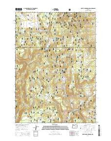
~ Myrtle Park Meadows OR topo map, 1:24000 scale, 7.5 X 7.5 Minute, Current, 2014
Myrtle Park Meadows, Oregon, USGS topographic map dated 2014.
Includes geographic coordinates (latitude and longitude). This topographic map is suitable for hiking, camping, and exploring, or framing it as a wall map.
Printed on-demand using high resolution imagery, on heavy weight and acid free paper, or alternatively on a variety of synthetic materials.
Topos available on paper, Waterproof, Poly, or Tyvek. Usually shipping rolled, unless combined with other folded maps in one order.
- Product Number: USGS-7253528
- Free digital map download (high-resolution, GeoPDF): Myrtle Park Meadows, Oregon (file size: 40 MB)
- Map Size: please refer to the dimensions of the GeoPDF map above
- Weight (paper map): ca. 55 grams
- Map Type: POD USGS Topographic Map
- Map Series: US Topo
- Map Verison: Current
- Cell ID: 31248
- Datum: North American Datum of 1983
- Map Projection: Transverse Mercator
- Map Cell Name: Myrtle Park Meadows
- Grid size: 7.5 X 7.5 Minute
- Date on map: 2014
- Map Scale: 1:24000
- Geographical region: Oregon, United States
Neighboring Maps:
All neighboring USGS topo maps are available for sale online at a variety of scales.
Spatial coverage:
Topo map Myrtle Park Meadows, Oregon, covers the geographical area associated the following places:
- Pipe Clamp Spring - Burnt Mountain - Sage Hen Creek - Hopper Spring - Little Sage Hen Flat - Clemens Ranch - Little Sage Hen Creek - Old Road Camp Spring - Myrtle Park Meadows - Fern Spring - L N Spring - Chesmore Spring - Mike Robinson Spring - Little Sage Hen Spring - West Myrtle Creek - H J Spring - Spear F Spring - Burnt Mountain Spring - Craddock Spring - Craddock Meadows - Boulder Spring - Gold Hill - Myrtle Spring - XI Spring - Burnt Mountain Meadows - Mud Flat - Crane Creek - Rawhide Spring - Bennett Cabin - Three E Spring - Bellows Creek - Gold Creek - Bellows Spring - F L Spring - Pheasant Spring - Burnt Mountain - Boulder Creek - Stancliffe Creek - Aspen Spring - Crane Flats - Ice Creek - Big Sage Hen Spring - Cottonwood Spring - Fawn Creek
- Map Area ID: AREA4443.875-119.125-119
- Northwest corner Lat/Long code: USGSNW44-119.125
- Northeast corner Lat/Long code: USGSNE44-119
- Southwest corner Lat/Long code: USGSSW43.875-119.125
- Southeast corner Lat/Long code: USGSSE43.875-119
- Northern map edge Latitude: 44
- Southern map edge Latitude: 43.875
- Western map edge Longitude: -119.125
- Eastern map edge Longitude: -119


